Source List
API endpoint that allows TempSpatial objects to be viewed or edited.
GET /api/source/?format=api
{ "count": 127, "next": "https://histogis.acdh.oeaw.ac.at/api/source/?format=api&limit=25&offset=25", "previous": null, "results": [ { "name": "Austrian Empire Stateborders 1815", "description": "The data set is mostly based on 2 maps of Austria from 1835 (Woldan: Floder, Oesterreich, 1835) and 1856 (Woldan: Czoernig, Oesterreich, 1856) available through Sammlung Woldan.\r\n\r\nIn order to improve geometry accuracy also other available vector data sets were used and adapted, viz.: data provided by\r\n\r\nthe Mosaic Project, funded by the Austrian Science Fund (FWF) (Project Number: P 21257, http://www.censusmosaic.org/) and\r\nthe © OpenStreetMap collaborative project (www.openstreetmap.org).\r\nAnna Piechl was responsible for map vectorization, reviewing existing data, for data consolidation and harmonization, and for data editing based on research by Peter Paul Marckhgott-Sanabria. Peter Paul Marckhgott-Sanabria was responsible for historical investigation and validation, in particular for reviewing the created data sets, for data harmonization and for research on administrative structures in the time period and on the dates of existence of the respective administrative units (time spans between formation and disintegration).\r\n\r\nFor the border of Kraków a map from the Silesian library in Katowice was used (Eduś - IBR Biblioteki Śląskiej w Katowicach; Jaworzno, 2015).", "quote": "Anna Piechl / Peter Paul Marckhgott-Sanabria, \"Austrian Empire 1815\", based on Woldan: Floder, Oesterreich, 1835; Woldan: Czoernig, Oesterreich, 1856; Census Mosaic: Europe Main, 1900; and © OpenStreetMap contributors; published by HistoGIS", "original_url": "http://sammlung.woldan.oeaw.ac.at/layers/geonode:ac03763400_oegqmst_oesterreich_gesamttitel_1835 http://sammlung.woldan.oeaw.ac.at/layers/geonode:ac03793289_czoernig_oesterreich_1856 http://www.censusmosaic.org/mosaic/tmp/download/europe_1900-2003.zip https://www.openstreetmap.org/; https://www.openstreetmap.org/copyright https://wambachers-osm.website/boundaries/" }, { "name": "Austrian Empire Stateborders 1848", "description": "The data set is mostly based on 2 maps of Austria from 1835 (Woldan: Floder, Oesterreich, 1835) and 1856 (Woldan: Czoernig, Oesterreich, 1856) available through Sammlung Woldan.\r\n\r\nIn order to improve geometry accuracy also other available vector data sets were used and adapted, viz.: data provided by\r\n\r\nthe Mosaic Project, funded by the Austrian Science Fund (FWF) (Project Number: P 21257, http://www.censusmosaic.org/) and\r\nthe © OpenStreetMap collaborative project (www.openstreetmap.org).\r\nFor the border of Kraków a map from the Silesian library in Katowice was used (Eduś - IBR Biblioteki Śląskiej w Katowicach, Jaworzno, 2015).\r\n\r\nAnna Piechl was responsible for reviewing the existing, provided data sets, for data consolidation and harmonization, and for data editing based on research by Peter Paul Marckhgott-Sanabria. Peter Paul Marckhgott-Sanabria was responsible for historical investigation and validation, in particular for reviewing the created data sets, for data harmonization and for research on administrative structures in the time period and on the dates of existence of the respective administrative units (time spans between formation and disintegration).", "quote": "Anna Piechl / Peter Paul Marckhgott-Sanabria, \"Austrian Empire 1848\", based on Woldan: Floder, Oesterreich, 1835; Woldan: Czoernig, Oesterreich, 1856; Census Mosaic: Europe Main, 1900; Eduś - IBR Biblioteki Śląskiej w Katowicach, Jaworzno, 2015 and © OpenStreetMap contributors; published by HistoGIS", "original_url": "http://sammlung.woldan.oeaw.ac.at/layers/geonode:ac03763400_oegqmst_oesterreich_gesamttitel_1835 http://sammlung.woldan.oeaw.ac.at/layers/geonode:ac03793289_czoernig_oesterreich_1856 http://www.censusmosaic.org/mosaic/tmp/download/europe_1900-2003.zip https://www.openstreetmap.org/; https://www.openstreetmap.org/copyright https://wambachers-osm.website/boundaries/ http://edus.ibrbs.pl/wp-content/uploads/2016/07/Mapa_16.jpg" }, { "name": "Austrian Empire Stateborders 1860", "description": "The data set is mostly based on 2 maps of Austria from 1835 (Woldan: Floder, Oesterreich, 1835) and 1856 (Woldan: Czoernig, Oesterreich, 1856) available through Sammlung Woldan.\r\n\r\nIn order to improve geometry accuracy also other available vector data sets were used and adapted, viz.: data provided by\r\n\r\nthe Mosaic Project, funded by the Austrian Science Fund (FWF) (Project Number: P 21257, http://www.censusmosaic.org/) and\r\nthe © OpenStreetMap collaborative project (www.openstreetmap.org).\r\nthe Geo-Larhra Catalogue (http://geo-larhra.org/?q=geocatalogue/vectors)\r\nFor the border of Kraków a map from the Silesian library in Katowice was used (Eduś - IBR Biblioteki Śląskiej w Katowicach; Jaworzno, 2015).\r\n\r\nAnna Piechl was responsible for map vectorization, reviewing existing data, for data consolidation and harmonization, and for data editing based on research by Peter Paul Marckhgott-Sanabria. Peter Paul Marckhgott-Sanabria was responsible for historical investigation and validation, in particular for reviewing the created data sets, for data harmonization and for research on administrative structures in the time period and on the dates of existence of the respective administrative units (time spans between formation and disintegration).", "quote": "Anna Piechl / Peter Paul Marckhgott-Sanabria, \"Austrian Empire 1860\", based on Woldan: Floder, Österreich, 1835; Woldan: Czoernig, Oesterreich, 1856; Census Mosaic: Europe Main, 1900; Eduś - IBR Biblioteki Śląskiej w Katowicach, Jaworzno, 2015 and © OpenStreetMap contributors; published by HistoGIS", "original_url": "http://sammlung.woldan.oeaw.ac.at/layers/geonode:ac03763400_oegqmst_oesterreich_gesamttitel_1835 http://www.censusmosaic.org/mosaic/tmp/download/europe_1900-2003.zip https://www.openstreetmap.org/; https://www.openstreetmap.org/copyright https://wambachers-osm.website/boundaries/ http://geo-larhra.org/?q=geocatalogue/vectors http://edus.ibrbs.pl/wp-content/uploads/2016/07/Mapa_16.jpg" }, { "name": "Austrian Empire Stateborders 1867", "description": "The data set is mostly based on 2 maps of Austria from 1835 (Woldan: Floder, Oesterreich, 1835) and 1856 (Woldan: Czoernig, Oesterreich, 1856) available through Sammlung Woldan.\r\n\r\nIn order to improve geometry accuracy also other available vector data sets were used and adapted, viz.: data provided by\r\n\r\nthe Mosaic Project, funded by the Austrian Science Fund (FWF) (Project Number: P 21257, http://www.censusmosaic.org/) and\r\nfor controlling the borders of Hungary and Transylvania a map from Richard Andree and Albert Scobel (Rumsey: Andree, Scobel, Ungarn und Galizien, 1940) from 1904 was used.\r\nto check the borders from Carinthia and the Austrian Littoral also a map from Andree and Scobel was used (Rumsey: Andree, Scobel, Nieder- und Ober- Österreich, 1905)\r\nthe © OpenStreetMap collaborative project (www.openstreetmap.org).\r\nFor the border of Kraków a map from the Silesian library in Katowice was used (Eduś - IBR Biblioteki Śląskiej w Katowicach; Jaworzno, 2015).\r\n\r\nAnna Piechl was responsible for map vectorization, reviewing existing data, for data consolidation and harmonization, and for data editing based on research by Peter Paul Marckhgott-Sanabria. Peter Paul Marckhgott-Sanabria was responsible for historical investigation and validation, in particular for reviewing the created data sets, for data harmonization and for research on administrative structures in the time period and on the dates of existence of the respective administrative units (time spans between formation and disintegration).", "quote": "Anna Piechl / Peter Paul Marckhgott-Sanabria, \"Austrian Empire 1867\", based on Woldan: Floder, Österreich, 1835 and Woldan: Czoernig, Oesterreich, 1856; Census Mosaic: Europe Main, 1900; Eduś - IBR Biblioteki Śląskiej w Katowicach, Jaworzno, 2015 and © OpenStreetMap contributors; published by Histogis", "original_url": "http://sammlung.woldan.oeaw.ac.at/layers/geonode:ac03763400_oegqmst_oesterreich_gesamttitel_1835 http://sammlung.woldan.oeaw.ac.at/layers/geonode:ac03793289_czoernig_oesterreich_1856 https://www.davidrumsey.com/luna/servlet/detail/RUMSEY~8~1~239320~5511735:Ungarn-und-Galizien?sort=Pub_List_No_InitialSort%2CPub_Date%2CPub_List_No%2CSeries_No&qvq=q:ungarn;sort:Pub_List_No_InitialSort%2CPub_Date%2CPub_List_No%2CSeries_No;lc:RUMSEY~8~1&mi=52&trs=150# https://www.davidrumsey.com/luna/servlet/detail/RUMSEY~8~1~239323~5511736:Nieder---und-Ober---Osterreich,-Ste?sort=Pub_List_No_InitialSort%2CPub_Date%2CPub_List_No%2CSeries_No&qvq=q:kärnten;sort:Pub_List_No_InitialSort%2CPub_Date%2CPub_List_No%2CSeries_No;lc:RUMSEY~8~1&mi=0&trs=2# http://www.censusmosaic.org/mosaic/tmp/download/europe_1900-2003.zip https://www.openstreetmap.org/; https://www.openstreetmap.org/copyright https://wambachers-osm.website/boundaries/ http://edus.ibrbs.pl/wp-content/uploads/2016/07/Mapa_16.jpg" }, { "name": "Austrian Empire Crownlands 1815", "description": "The basis of this data set is build on a map of Austria from 1835 by Anton Floder available through Sammlung Woldan. To adapt the data set and to provide widely harmonized data, also for the following decades, other historical maps were used as well for cross checking the borders and for data amendment. Following maps were used for comparing and adjusting the data set:\r\n\r\nKoenigreich Ungarn mit Kroazien, Slavonien, 1835 by Streit and Fischer (Rumsey Collection)\r\nBöhmen, Mähren und Osterreichisch-Schlesie, 1905 by Andree and Scobel (Rumsey Collection)\r\nKärnthen, Krain, Görz-Gradisca, Istrien, Triest, 1855 by Flemming (Rumsey Collection)\r\nGalizien, Ungarn und Nebenländer, 1868 by Kiepert (Rumsey Collection)\r\nDas Koenigreich Galizien, 1832 by Geographisches Institut (Weimar), Weiland (Rumsey Collection)\r\nOesterreich, 1849 by Radefeld (Rumsey Collection)\r\nJaworzno - w granicach Rzecpospolitej Krakowskiej w latach, 1815-1846\r\nIn order to improve geometry accuracy also other available vector data sets were used and adapted, viz.: data provided by\r\n\r\nthe Mosaic Project, funded by the Austrian Science Fund (FWF) (Project Number: P 21257, http://www.censusmosaic.org/) and\r\nthe © OpenStreetMap collaborative project (www.openstreetmap.org).\r\nAnna Piechl was responsible for reviewing the existing, provided data sets, for data consolidation and harmonization, and for data editing based on research by Peter Paul Marckhgott-Sanabria. Peter Paul Marckhgott-Sanabria was responsible for historical investigation and validation, in particular for reviewing the created data sets, for data harmonization and for research on administrative structures in the time period and on the dates of existence of the respective administrative units (time spans between formation and disintegration).", "quote": "Anna Piechl / Peter Paul Marckhgott-Sanabria, \"Austrian Empire Crownlands 1848\", based on Woldan: Floder, Österreich, 1835; Census Mosaic: Europe Main, 1900; Rumsey: Andree, Scobel, Böhmen, 1905; Rumsey: Radefeld, Oesterreich, 1849; Rumsey: Streit, Ungarn, 1835; Rumsey: GI Weimar, Galizien, 1832; Rumsey: Andree, Böhmen, 1905; Rumsey: Flemming, Kärnthen, 1855; 2015 and © OpenStreetMap contributors; published by Histogis", "original_url": "http://sammlung.woldan.oeaw.ac.at/layers/geonode:ac03763400_oegqmst_oesterreich_gesamttitel_1835 http://www.censusmosaic.org/mosaic/tmp/download/europe_1900-2003.zip https://www.openstreetmap.org/; https://www.openstreetmap.org/copyright https://wambachers-osm.website/boundaries/ https://www.davidrumsey.com/luna/servlet/detail/RUMSEY~8~1~314315~90083474:Koenigreich-Ungarn-mit-Kroazien,-Sl?sort=Pub_List_No_InitialSort%2CPub_Date%2CPub_List_No%2CSeries_No&qvq=q:ungarn;sort:Pub_List_No_InitialSort%2CPub_Date%2CPub_List_No%2CSeries_No;lc:RUMSEY~8~1&mi=42&trs=150# https://www.davidrumsey.com/luna/servlet/detail/RUMSEY~8~1~239318~5511734:Bohmen,-Mahren-und-Osterreichisch-S?sort=pub_list_no_initialsort%2Cpub_date%2Cpub_list_no%2Cseries_no&qvq=q:mähren;sort:pub_list_no_initialsort%2Cpub_date%2Cpub_list_no%2Cseries_no;lc:RUMSEY~8~1&mi=6&trs=19# https://www.davidrumsey.com/luna/servlet/detail/RUMSEY~8~1~33462~1170948:Karnthen,-Krain,-Gorz-Gradisca,-Ist?sort=pub_list_no_initialsort%2Cpub_date%2Cpub_list_no%2Cseries_no&qvq=q:karnthen;sort:pub_list_no_initialsort%2Cpub_date%2Cpub_list_no%2Cseries_no;lc:RUMSEY~8~1&mi=4&trs=5 https://www.davidrumsey.com/luna/servlet/detail/RUMSEY~8~1~303778~90074534:Galizien,-Ungarn-und-Nebenlander?sort=Pub_List_No_InitialSort%2CPub_Date%2CPub_List_No%2CSeries_No&qvq=q:ungarn;sort:Pub_List_No_InitialSort%2CPub_Date%2CPub_List_No%2CSeries_No;lc:RUMSEY~8~1&mi=41&trs=150 https://www.davidrumsey.com/luna/servlet/detail/RUMSEY~8~1~280029~90053299:Das-Koenigreich-Galizien--Kingdom-o?sort=pub_list_no_initialsort%2Cpub_date%2Cpub_list_no%2Cseries_no&qvq=w4s:/when%2F1832;q:galizien;sort:pub_list_no_initialsort%2Cpub_date%2Cpub_list_no%2Cseries_no;lc:RUMSEY~8~1&mi=0&trs=1 https://www.davidrumsey.com/luna/servlet/detail/RUMSEY~8~1~21892~680048:Composite--Oesterreich-?sort=Pub_List_No_InitialSort%2CPub_Date%2CPub_List_No%2CSeries_No&qvq=q:enns;sort:Pub_List_No_InitialSort%2CPub_Date%2CPub_List_No%2CSeries_No;lc:RUMSEY~8~1&mi=12&trs=207" }, { "name": "Austrian Empire Crownlands 1848", "description": "The basis of this data set is build on a map of Austria from 1835 by Anton Floder available through Sammlung Woldan. To adapt the data set and to provide widely harmonized data, also for the following decades, other historical maps were used as well for cross checking the borders and for data amendment. Following maps were used for comparing and adjusting the data set:\r\n\r\nKoenigreich Ungarn mit Kroazien, Slavonien, 1835 by Streit and Fischer (Rumsey Collection)\r\nBöhmen, Mähren und Osterreichisch-Schlesie, 1905 by Andree and Scobel (Rumsey Collection)\r\nKärnthen, Krain, Görz-Gradisca, Istrien, Triest, 1855 by Flemming (Rumsey Collection)\r\nGalizien, Ungarn und Nebenländer, 1868 by Kiepert (Rumsey Collection)\r\nDas Koenigreich Galizien, 1832 by Geographisches Institut (Weimar), Weiland (Rumsey Collection)\r\nOesterreich, 1849 by Radefeld (Rumsey Collection)\r\nJaworzno - w granicach Rzecpospolitej Krakowskiej w latach, 1815-1846\r\nIn order to improve geometry accuracy also other available vector data sets were used and adapted, viz.: data provided by\r\n\r\nthe Mosaic Project, funded by the Austrian Science Fund (FWF) (Project Number: P 21257, http://www.censusmosaic.org/) and\r\nthe © OpenStreetMap collaborative project (www.openstreetmap.org).\r\nAnna Piechl was responsible for reviewing the existing, provided data sets, for data consolidation and harmonization, and for data editing based on research by Peter Paul Marckhgott-Sanabria. Peter Paul Marckhgott-Sanabria was responsible for historical investigation and validation, in particular for reviewing the created data sets, for data harmonization and for research on administrative structures in the time period and on the dates of existence of the respective administrative units (time spans between formation and disintegration).", "quote": "Anna Piechl / Peter Paul Marckhgott-Sanabria, \"Austrian Empire Crownlands 1848\", based on Woldan: Floder, Österreich, 1835; Census Mosaic: Europe Main, 1900; Rumsey: Andree, Scobel, Böhmen, 1905; Rumsey: Radefeld, Oesterreich, 1849; Rumsey: Streit, Ungarn, 1835; Rumsey: GI Weimar, Galizien, 1832; Rumsey: Andree, Böhmen, 1905; Rumsey: Flemming, Kärnthen, 1855; Eduś - IBR Biblioteki Śląskiej w Katowicach, Jaworzno, 2015 and © OpenStreetMap contributors; published by Histogis", "original_url": "http://sammlung.woldan.oeaw.ac.at/layers/geonode:ac03763400_oegqmst_oesterreich_gesamttitel_1835 http://www.censusmosaic.org/mosaic/tmp/download/europe_1900-2003.zip https://www.openstreetmap.org/; https://www.openstreetmap.org/copyright https://wambachers-osm.website/boundaries/ https://www.davidrumsey.com/luna/servlet/detail/RUMSEY~8~1~314315~90083474:Koenigreich-Ungarn-mit-Kroazien,-Sl?sort=Pub_List_No_InitialSort%2CPub_Date%2CPub_List_No%2CSeries_No&qvq=q:ungarn;sort:Pub_List_No_InitialSort%2CPub_Date%2CPub_List_No%2CSeries_No;lc:RUMSEY~8~1&mi=42&trs=150# https://www.davidrumsey.com/luna/servlet/detail/RUMSEY~8~1~239318~5511734:Bohmen,-Mahren-und-Osterreichisch-S?sort=pub_list_no_initialsort%2Cpub_date%2Cpub_list_no%2Cseries_no&qvq=q:mähren;sort:pub_list_no_initialsort%2Cpub_date%2Cpub_list_no%2Cseries_no;lc:RUMSEY~8~1&mi=6&trs=19# https://www.davidrumsey.com/luna/servlet/detail/RUMSEY~8~1~33462~1170948:Karnthen,-Krain,-Gorz-Gradisca,-Ist?sort=pub_list_no_initialsort%2Cpub_date%2Cpub_list_no%2Cseries_no&qvq=q:karnthen;sort:pub_list_no_initialsort%2Cpub_date%2Cpub_list_no%2Cseries_no;lc:RUMSEY~8~1&mi=4&trs=5 https://www.davidrumsey.com/luna/servlet/detail/RUMSEY~8~1~303778~90074534:Galizien,-Ungarn-und-Nebenlander?sort=Pub_List_No_InitialSort%2CPub_Date%2CPub_List_No%2CSeries_No&qvq=q:ungarn;sort:Pub_List_No_InitialSort%2CPub_Date%2CPub_List_No%2CSeries_No;lc:RUMSEY~8~1&mi=41&trs=150 https://www.davidrumsey.com/luna/servlet/detail/RUMSEY~8~1~280029~90053299:Das-Koenigreich-Galizien--Kingdom-o?sort=pub_list_no_initialsort%2Cpub_date%2Cpub_list_no%2Cseries_no&qvq=w4s:/when%2F1832;q:galizien;sort:pub_list_no_initialsort%2Cpub_date%2Cpub_list_no%2Cseries_no;lc:RUMSEY~8~1&mi=0&trs=1 https://www.davidrumsey.com/luna/servlet/detail/RUMSEY~8~1~21892~680048:Composite--Oesterreich-?sort=Pub_List_No_InitialSort%2CPub_Date%2CPub_List_No%2CSeries_No&qvq=q:enns;sort:Pub_List_No_InitialSort%2CPub_Date%2CPub_List_No%2CSeries_No;lc:RUMSEY~8~1&mi=12&trs=207 http://edus.ibrbs.pl/wp-content/uploads/2016/07/Mapa_16.jpg" }, { "name": "Austrian Empire Crownlands 1849", "description": "The basis of this data set is build on a map of Austria from 1835 by Anton Floder available through Sammlung Woldan. To adapt the data set and to provide widely harmonized data, also for the following decades, other historical maps were used as well for cross checking the borders and for data amendment. Following maps were used for comparing and adjusting the data set:\r\n\r\nKoenigreich Ungarn mit Kroazien, Slavonien, 1835 by Streit and Fischer (Rumsey Collection)\r\nBöhmen, Mähren und Osterreichisch-Schlesie, 1905 by Andree and Scobel (Rumsey Collection)\r\nKärnthen, Krain, Görz-Gradisca, Istrien, Triest, 1855 by Flemming (Rumsey Collection)\r\nGalizien, Ungarn und Nebenländer, 1868 by Kiepert (Rumsey Collection)\r\nDas Koenigreich Galizien, 1832 by Geographisches Institut (Weimar), Weiland (Rumsey Collection)\r\nOesterreich, 1849 by Radefeld (Rumsey Collection)\r\nJaworzno - w granicach Rzecpospolitej Krakowskiej w latach, 1815-1846\r\nIn order to improve geometry accuracy also other available vector data sets were used and adapted, viz.: data provided by\r\n\r\nthe Mosaic Project, funded by the Austrian Science Fund (FWF) (Project Number: P 21257, http://www.censusmosaic.org/) and\r\nthe © OpenStreetMap collaborative project (www.openstreetmap.org).\r\nAnna Piechl was responsible for reviewing the existing, provided data sets, for data consolidation and harmonization, and for data editing based on research by Peter Paul Marckhgott-Sanabria. Peter Paul Marckhgott-Sanabria was responsible for historical investigation and validation, in particular for reviewing the created data sets, for data harmonization and for research on administrative structures in the time period and on the dates of existence of the respective administrative units (time spans between formation and disintegration).", "quote": "Anna Piechl / Peter Paul Marckhgott-Sanabria, \"Austrian Empire Crownlands 1849\", based on Woldan: Floder, Österreich, 1835; Census Mosaic: Europe Main, 1900; Rumsey: Andree, Scobel, Böhmen, 1905; Rumsey: Radefeld, Oesterreich, 1849; Rumsey: Streit, Ungarn, 1835; Rumsey: GI Weimar, Galizien, 1832; Rumsey: Andree, Böhmen, 1905; Rumsey: Flemming, Kärnthen, 1855; Eduś - IBR Biblioteki Śląskiej w Katowicach, Jaworzno, 2015 and © OpenStreetMap contributors; published by Histogis", "original_url": "http://sammlung.woldan.oeaw.ac.at/layers/geonode:ac03763400_oegqmst_oesterreich_gesamttitel_1835 http://www.censusmosaic.org/mosaic/tmp/download/europe_1900-2003.zip https://www.openstreetmap.org/; https://www.openstreetmap.org/copyright https://wambachers-osm.website/boundaries/ https://www.davidrumsey.com/luna/servlet/detail/RUMSEY~8~1~314315~90083474:Koenigreich-Ungarn-mit-Kroazien,-Sl?sort=Pub_List_No_InitialSort%2CPub_Date%2CPub_List_No%2CSeries_No&qvq=q:ungarn;sort:Pub_List_No_InitialSort%2CPub_Date%2CPub_List_No%2CSeries_No;lc:RUMSEY~8~1&mi=42&trs=150# https://www.davidrumsey.com/luna/servlet/detail/RUMSEY~8~1~239318~5511734:Bohmen,-Mahren-und-Osterreichisch-S?sort=pub_list_no_initialsort%2Cpub_date%2Cpub_list_no%2Cseries_no&qvq=q:mähren;sort:pub_list_no_initialsort%2Cpub_date%2Cpub_list_no%2Cseries_no;lc:RUMSEY~8~1&mi=6&trs=19# https://www.davidrumsey.com/luna/servlet/detail/RUMSEY~8~1~33462~1170948:Karnthen,-Krain,-Gorz-Gradisca,-Ist?sort=pub_list_no_initialsort%2Cpub_date%2Cpub_list_no%2Cseries_no&qvq=q:karnthen;sort:pub_list_no_initialsort%2Cpub_date%2Cpub_list_no%2Cseries_no;lc:RUMSEY~8~1&mi=4&trs=5 https://www.davidrumsey.com/luna/servlet/detail/RUMSEY~8~1~303778~90074534:Galizien,-Ungarn-und-Nebenlander?sort=Pub_List_No_InitialSort%2CPub_Date%2CPub_List_No%2CSeries_No&qvq=q:ungarn;sort:Pub_List_No_InitialSort%2CPub_Date%2CPub_List_No%2CSeries_No;lc:RUMSEY~8~1&mi=41&trs=150 https://www.davidrumsey.com/luna/servlet/detail/RUMSEY~8~1~280029~90053299:Das-Koenigreich-Galizien--Kingdom-o?sort=pub_list_no_initialsort%2Cpub_date%2Cpub_list_no%2Cseries_no&qvq=w4s:/when%2F1832;q:galizien;sort:pub_list_no_initialsort%2Cpub_date%2Cpub_list_no%2Cseries_no;lc:RUMSEY~8~1&mi=0&trs=1 https://www.davidrumsey.com/luna/servlet/detail/RUMSEY~8~1~21892~680048:Composite--Oesterreich-?sort=Pub_List_No_InitialSort%2CPub_Date%2CPub_List_No%2CSeries_No&qvq=q:enns;sort:Pub_List_No_InitialSort%2CPub_Date%2CPub_List_No%2CSeries_No;lc:RUMSEY~8~1&mi=12&trs=207 http://edus.ibrbs.pl/wp-content/uploads/2016/07/Mapa_16.jpg" }, { "name": "Austrian Empire Crownlands 1850", "description": "The basis of this data set is build on a map of Austria from 1835 by Anton Floder available through Sammlung Woldan. To adapt the data set and to provide widely harmonized data, also for the following decades, other historical maps were used as well for cross checking the borders and for data amendment. Following maps were used for comparing and adjusting the data set:\r\n\r\nKoenigreich Ungarn mit Kroazien, Slavonien, 1835 by Streit and Fischer (Rumsey Collection)\r\nBöhmen, Mähren und Osterreichisch-Schlesie, 1905 by Andree and Scobel (Rumsey Collection)\r\nKärnthen, Krain, Görz-Gradisca, Istrien, Triest, 1855 by Flemming (Rumsey Collection)\r\nGalizien, Ungarn und Nebenländer, 1868 by Kiepert (Rumsey Collection)\r\nDas Koenigreich Galizien, 1832 by Geographisches Institut (Weimar), Weiland (Rumsey Collection)\r\nOesterreich, 1849 by Radefeld (Rumsey Collection)\r\nJaworzno - w granicach Rzecpospolitej Krakowskiej w latach, 1815-1846\r\nDie Herzogthumer Steiermark, Karnten, Krain, 1866, Geographisches Institut (Weimar)\r\nUngarn, Galizien, 1855, by Kiepert (Rumsey Collection)\r\nOesterreich, 1856 by Czoernig (Woldan Collection)\r\nIn order to improve geometry accuracy also other available vector data sets were used and adapted, viz.: data provided by\r\n\r\nthe Mosaic Project, funded by the Austrian Science Fund (FWF) (Project Number: P 21257, http://www.censusmosaic.org/) and\r\nthe © OpenStreetMap collaborative project (www.openstreetmap.org).\r\nAnna Piechl was responsible for reviewing the existing, provided data sets, for data consolidation and harmonization, and for data editing based on research by Peter Paul Marckhgott-Sanabria. Peter Paul Marckhgott-Sanabria was responsible for historical investigation and validation, in particular for reviewing the created data sets, for data harmonization and for research on administrative structures in the time period and on the dates of existence of the respective administrative units (time spans between formation and disintegration).", "quote": "Anna Piechl / Peter Paul Marckhgott-Sanabria, \"Austrian Empire Crownlands 1850\", based on Woldan: Floder, Österreich, 1835; Census Mosaic: Europe Main, 1900; Rumsey: Andree, Scobel, Böhmen, 1905; Rumsey: Radefeld, Oesterreich, 1849; Rumsey: Streit, Ungarn, 1835; Rumsey: GI Weimar, Galizien, 1832; Rumsey: Andree, Böhmen, 1905; Rumsey: Flemming, Kärnthen, 1855; Eduś - IBR Biblioteki Śląskiej w Katowicach, Jaworzno, 2015; Woldan: Czoernig, Oesterreich, 1856 and © OpenStreetMap contributors; published by Histogis", "original_url": "http://sammlung.woldan.oeaw.ac.at/layers/geonode:ac03763400_oegqmst_oesterreich_gesamttitel_1835 http://www.censusmosaic.org/mosaic/tmp/download/europe_1900-2003.zip https://www.openstreetmap.org/; https://www.openstreetmap.org/copyright https://wambachers-osm.website/boundaries/ https://www.davidrumsey.com/luna/servlet/detail/RUMSEY~8~1~314315~90083474:Koenigreich-Ungarn-mit-Kroazien,-Sl?sort=Pub_List_No_InitialSort%2CPub_Date%2CPub_List_No%2CSeries_No&qvq=q:ungarn;sort:Pub_List_No_InitialSort%2CPub_Date%2CPub_List_No%2CSeries_No;lc:RUMSEY~8~1&mi=42&trs=150# https://www.davidrumsey.com/luna/servlet/detail/RUMSEY~8~1~239318~5511734:Bohmen,-Mahren-und-Osterreichisch-S?sort=pub_list_no_initialsort%2Cpub_date%2Cpub_list_no%2Cseries_no&qvq=q:mähren;sort:pub_list_no_initialsort%2Cpub_date%2Cpub_list_no%2Cseries_no;lc:RUMSEY~8~1&mi=6&trs=19# https://www.davidrumsey.com/luna/servlet/detail/RUMSEY~8~1~33462~1170948:Karnthen,-Krain,-Gorz-Gradisca,-Ist?sort=pub_list_no_initialsort%2Cpub_date%2Cpub_list_no%2Cseries_no&qvq=q:karnthen;sort:pub_list_no_initialsort%2Cpub_date%2Cpub_list_no%2Cseries_no;lc:RUMSEY~8~1&mi=4&trs=5 https://www.davidrumsey.com/luna/servlet/detail/RUMSEY~8~1~303778~90074534:Galizien,-Ungarn-und-Nebenlander?sort=Pub_List_No_InitialSort%2CPub_Date%2CPub_List_No%2CSeries_No&qvq=q:ungarn;sort:Pub_List_No_InitialSort%2CPub_Date%2CPub_List_No%2CSeries_No;lc:RUMSEY~8~1&mi=41&trs=150 https://www.davidrumsey.com/luna/servlet/detail/RUMSEY~8~1~280029~90053299:Das-Koenigreich-Galizien--Kingdom-o?sort=pub_list_no_initialsort%2Cpub_date%2Cpub_list_no%2Cseries_no&qvq=w4s:/when%2F1832;q:galizien;sort:pub_list_no_initialsort%2Cpub_date%2Cpub_list_no%2Cseries_no;lc:RUMSEY~8~1&mi=0&trs=1 https://www.davidrumsey.com/luna/servlet/detail/RUMSEY~8~1~21892~680048:Composite--Oesterreich-?sort=Pub_List_No_InitialSort%2CPub_Date%2CPub_List_No%2CSeries_No&qvq=q:enns;sort:Pub_List_No_InitialSort%2CPub_Date%2CPub_List_No%2CSeries_No;lc:RUMSEY~8~1&mi=12&trs=207 http://edus.ibrbs.pl/wp-content/uploads/2016/07/Mapa_16.jpg https://www.davidrumsey.com/luna/servlet/detail/RUMSEY~8~1~265853~90040373:Die-Herzogthumer-Steiermark,-Karnte?sort=Pub_List_No_InitialSort%2CPub_Date%2CPub_List_No%2CSeries_No&qvq=q:krain;sort:Pub_List_No_InitialSort%2CPub_Date%2CPub_List_No%2CSeries_No;lc:RUMSEY~8~1&mi=12&trs=18 https://www.davidrumsey.com/luna/servlet/detail/RUMSEY~8~1~24743~950007:Ungarn,-Galizien-?sort=Pub_List_No_InitialSort%2CPub_Date%2CPub_List_No%2CSeries_No&qvq=w4s:/when%2F1855;q:kiepert;sort:Pub_List_No_InitialSort%2CPub_Date%2CPub_List_No%2CSeries_No;lc:RUMSEY~8~1&mi=0&trs=12 http://sammlung.woldan.oeaw.ac.at/layers/geonode:ac03793289_czoernig_oesterreich_1856" }, { "name": "Austrian Empire Crownlands 1851", "description": "The basis of this data set is build on a map of Austria from 1835 by Anton Floder available through Sammlung Woldan. To adapt the data set and to provide widely harmonized data, also for the following decades, other historical maps were used as well for cross checking the borders and for data amendment. Following maps were used for comparing and adjusting the data set:\r\n\r\nKoenigreich Ungarn mit Kroazien, Slavonien, 1835 by Streit and Fischer (Rumsey Collection)\r\nBöhmen, Mähren und Osterreichisch-Schlesie, 1905 by Andree and Scobel (Rumsey Collection)\r\nKärnthen, Krain, Görz-Gradisca, Istrien, Triest, 1855 by Flemming (Rumsey Collection)\r\nGalizien, Ungarn und Nebenländer, 1868 by Kiepert (Rumsey Collection)\r\nDas Koenigreich Galizien, 1832 by Geographisches Institut (Weimar), Weiland (Rumsey Collection)\r\nOesterreich, 1849 by Radefeld (Rumsey Collection)\r\nJaworzno - w granicach Rzecpospolitej Krakowskiej w latach, 1815-1846\r\nDie Herzogthumer Steiermark, Karnten, Krain, 1866, Geographisches Institut (Weimar)\r\nUngarn, Galizien, 1855, by Kiepert (Rumsey Collection)\r\nOesterreich, 1856 by Czoernig (Woldan Collection)\r\nIn order to improve geometry accuracy also other available vector data sets were used and adapted, viz.: data provided by\r\n\r\nthe Mosaic Project, funded by the Austrian Science Fund (FWF) (Project Number: P 21257, http://www.censusmosaic.org/) and\r\nthe © OpenStreetMap collaborative project (www.openstreetmap.org).\r\nAnna Piechl was responsible for reviewing the existing, provided data sets, for data consolidation and harmonization, and for data editing based on research by Peter Paul Marckhgott-Sanabria. Peter Paul Marckhgott-Sanabria was responsible for historical investigation and validation, in particular for reviewing the created data sets, for data harmonization and for research on administrative structures in the time period and on the dates of existence of the respective administrative units (time spans between formation and disintegration).", "quote": "Anna Piechl / Peter Paul Marckhgott-Sanabria, \"Austrian Empire Crownlands 1851\", based on Woldan: Floder, Österreich, 1835; Census Mosaic: Europe Main, 1900; Rumsey: Andree, Scobel, Böhmen, 1905; Rumsey: Radefeld, Oesterreich, 1849; Rumsey: Streit, Ungarn, 1835; Rumsey: GI Weimar, Galizien, 1832; Rumsey: Andree, Böhmen, 1905; Rumsey: Flemming, Kärnthen, 1855; Eduś - IBR Biblioteki Śląskiej w Katowicach, Jaworzno, 2015; Woldan: Czoernig, Oesterreich, 1856 and © OpenStreetMap contributors; published by Histogis", "original_url": "http://sammlung.woldan.oeaw.ac.at/layers/geonode:ac03763400_oegqmst_oesterreich_gesamttitel_1835 http://www.censusmosaic.org/mosaic/tmp/download/europe_1900-2003.zip https://www.openstreetmap.org/; https://www.openstreetmap.org/copyright https://wambachers-osm.website/boundaries/ https://www.davidrumsey.com/luna/servlet/detail/RUMSEY~8~1~314315~90083474:Koenigreich-Ungarn-mit-Kroazien,-Sl?sort=Pub_List_No_InitialSort%2CPub_Date%2CPub_List_No%2CSeries_No&qvq=q:ungarn;sort:Pub_List_No_InitialSort%2CPub_Date%2CPub_List_No%2CSeries_No;lc:RUMSEY~8~1&mi=42&trs=150# https://www.davidrumsey.com/luna/servlet/detail/RUMSEY~8~1~239318~5511734:Bohmen,-Mahren-und-Osterreichisch-S?sort=pub_list_no_initialsort%2Cpub_date%2Cpub_list_no%2Cseries_no&qvq=q:mähren;sort:pub_list_no_initialsort%2Cpub_date%2Cpub_list_no%2Cseries_no;lc:RUMSEY~8~1&mi=6&trs=19# https://www.davidrumsey.com/luna/servlet/detail/RUMSEY~8~1~33462~1170948:Karnthen,-Krain,-Gorz-Gradisca,-Ist?sort=pub_list_no_initialsort%2Cpub_date%2Cpub_list_no%2Cseries_no&qvq=q:karnthen;sort:pub_list_no_initialsort%2Cpub_date%2Cpub_list_no%2Cseries_no;lc:RUMSEY~8~1&mi=4&trs=5 https://www.davidrumsey.com/luna/servlet/detail/RUMSEY~8~1~303778~90074534:Galizien,-Ungarn-und-Nebenlander?sort=Pub_List_No_InitialSort%2CPub_Date%2CPub_List_No%2CSeries_No&qvq=q:ungarn;sort:Pub_List_No_InitialSort%2CPub_Date%2CPub_List_No%2CSeries_No;lc:RUMSEY~8~1&mi=41&trs=150 https://www.davidrumsey.com/luna/servlet/detail/RUMSEY~8~1~280029~90053299:Das-Koenigreich-Galizien--Kingdom-o?sort=pub_list_no_initialsort%2Cpub_date%2Cpub_list_no%2Cseries_no&qvq=w4s:/when%2F1832;q:galizien;sort:pub_list_no_initialsort%2Cpub_date%2Cpub_list_no%2Cseries_no;lc:RUMSEY~8~1&mi=0&trs=1 https://www.davidrumsey.com/luna/servlet/detail/RUMSEY~8~1~21892~680048:Composite--Oesterreich-?sort=Pub_List_No_InitialSort%2CPub_Date%2CPub_List_No%2CSeries_No&qvq=q:enns;sort:Pub_List_No_InitialSort%2CPub_Date%2CPub_List_No%2CSeries_No;lc:RUMSEY~8~1&mi=12&trs=207 http://edus.ibrbs.pl/wp-content/uploads/2016/07/Mapa_16.jpg https://www.davidrumsey.com/luna/servlet/detail/RUMSEY~8~1~265853~90040373:Die-Herzogthumer-Steiermark,-Karnte?sort=Pub_List_No_InitialSort%2CPub_Date%2CPub_List_No%2CSeries_No&qvq=q:krain;sort:Pub_List_No_InitialSort%2CPub_Date%2CPub_List_No%2CSeries_No;lc:RUMSEY~8~1&mi=12&trs=18 https://www.davidrumsey.com/luna/servlet/detail/RUMSEY~8~1~24743~950007:Ungarn,-Galizien-?sort=Pub_List_No_InitialSort%2CPub_Date%2CPub_List_No%2CSeries_No&qvq=w4s:/when%2F1855;q:kiepert;sort:Pub_List_No_InitialSort%2CPub_Date%2CPub_List_No%2CSeries_No;lc:RUMSEY~8~1&mi=0&trs=12 http://sammlung.woldan.oeaw.ac.at/layers/geonode:ac03793289_czoernig_oesterreich_1856" }, { "name": "Austrian Empire Crownlands 1860", "description": "The basis of this data set is build on a map of Austria from 1835 by Anton Floder available through Sammlung Woldan. To adapt the data set and to provide widely harmonized data, also for the following decades, other historical maps were used as well for cross checking the borders and for data amendment. Following maps were used for comparing and adjusting the data set:\r\n\r\nKoenigreich Ungarn mit Kroazien, Slavonien, 1835 by Streit and Fischer (Rumsey Collection)\r\nBöhmen, Mähren und Osterreichisch-Schlesie, 1905 by Andree and Scobel (Rumsey Collection)\r\nKärnthen, Krain, Görz-Gradisca, Istrien, Triest, 1855 by Flemming (Rumsey Collection)\r\nGalizien, Ungarn und Nebenländer, 1868 by Kiepert (Rumsey Collection)\r\nDas Koenigreich Galizien, 1832 by Geographisches Institut (Weimar), Weiland (Rumsey Collection)\r\nOesterreich, 1849 by Radefeld (Rumsey Collection)\r\nJaworzno - w granicach Rzecpospolitej Krakowskiej w latach, 1815-1846\r\nDie Herzogthumer Steiermark, Karnten, Krain, 1866, Geographisches Institut (Weimar)\r\nUngarn, Galizien, 1855, by Kiepert (Rumsey Collection)\r\nOesterreich, 1856 by Czoernig (Woldan Collection)\r\nIn order to improve geometry accuracy also other available vector data sets were used and adapted, viz.: data provided by\r\n\r\nthe Mosaic Project, funded by the Austrian Science Fund (FWF) (Project Number: P 21257, http://www.censusmosaic.org/) and\r\nthe © OpenStreetMap collaborative project (www.openstreetmap.org).\r\nAnna Piechl was responsible for reviewing the existing, provided data sets, for data consolidation and harmonization, and for data editing based on research by Peter Paul Marckhgott-Sanabria. Peter Paul Marckhgott-Sanabria was responsible for historical investigation and validation, in particular for reviewing the created data sets, for data harmonization and for research on administrative structures in the time period and on the dates of existence of the respective administrative units (time spans between formation and disintegration).", "quote": "Anna Piechl / Peter Paul Marckhgott-Sanabria, \"Austrian Empire Crownlands 1860\", based on Woldan: Floder, Österreich, 1835; Census Mosaic: Europe Main, 1900; Rumsey: Andree, Scobel, Böhmen, 1905; Rumsey: Radefeld, Oesterreich, 1849; Rumsey: Streit, Ungarn, 1835; Rumsey: GI Weimar, Galizien, 1832; Rumsey: Andree, Böhmen, 1905; Rumsey: Flemming, Kärnthen, 1855; Eduś - IBR Biblioteki Śląskiej w Katowicach, Jaworzno, 2015; Woldan: Czoernig, Oesterreich, 1856 and © OpenStreetMap contributors; published by Histogis", "original_url": "http://sammlung.woldan.oeaw.ac.at/layers/geonode:ac03763400_oegqmst_oesterreich_gesamttitel_1835 http://www.censusmosaic.org/mosaic/tmp/download/europe_1900-2003.zip https://www.openstreetmap.org/; https://www.openstreetmap.org/copyright https://wambachers-osm.website/boundaries/ https://www.davidrumsey.com/luna/servlet/detail/RUMSEY~8~1~314315~90083474:Koenigreich-Ungarn-mit-Kroazien,-Sl?sort=Pub_List_No_InitialSort%2CPub_Date%2CPub_List_No%2CSeries_No&qvq=q:ungarn;sort:Pub_List_No_InitialSort%2CPub_Date%2CPub_List_No%2CSeries_No;lc:RUMSEY~8~1&mi=42&trs=150# https://www.davidrumsey.com/luna/servlet/detail/RUMSEY~8~1~239318~5511734:Bohmen,-Mahren-und-Osterreichisch-S?sort=pub_list_no_initialsort%2Cpub_date%2Cpub_list_no%2Cseries_no&qvq=q:mähren;sort:pub_list_no_initialsort%2Cpub_date%2Cpub_list_no%2Cseries_no;lc:RUMSEY~8~1&mi=6&trs=19# https://www.davidrumsey.com/luna/servlet/detail/RUMSEY~8~1~33462~1170948:Karnthen,-Krain,-Gorz-Gradisca,-Ist?sort=pub_list_no_initialsort%2Cpub_date%2Cpub_list_no%2Cseries_no&qvq=q:karnthen;sort:pub_list_no_initialsort%2Cpub_date%2Cpub_list_no%2Cseries_no;lc:RUMSEY~8~1&mi=4&trs=5 https://www.davidrumsey.com/luna/servlet/detail/RUMSEY~8~1~303778~90074534:Galizien,-Ungarn-und-Nebenlander?sort=Pub_List_No_InitialSort%2CPub_Date%2CPub_List_No%2CSeries_No&qvq=q:ungarn;sort:Pub_List_No_InitialSort%2CPub_Date%2CPub_List_No%2CSeries_No;lc:RUMSEY~8~1&mi=41&trs=150 https://www.davidrumsey.com/luna/servlet/detail/RUMSEY~8~1~280029~90053299:Das-Koenigreich-Galizien--Kingdom-o?sort=pub_list_no_initialsort%2Cpub_date%2Cpub_list_no%2Cseries_no&qvq=w4s:/when%2F1832;q:galizien;sort:pub_list_no_initialsort%2Cpub_date%2Cpub_list_no%2Cseries_no;lc:RUMSEY~8~1&mi=0&trs=1 https://www.davidrumsey.com/luna/servlet/detail/RUMSEY~8~1~21892~680048:Composite--Oesterreich-?sort=Pub_List_No_InitialSort%2CPub_Date%2CPub_List_No%2CSeries_No&qvq=q:enns;sort:Pub_List_No_InitialSort%2CPub_Date%2CPub_List_No%2CSeries_No;lc:RUMSEY~8~1&mi=12&trs=207 http://edus.ibrbs.pl/wp-content/uploads/2016/07/Mapa_16.jpg https://www.davidrumsey.com/luna/servlet/detail/RUMSEY~8~1~265853~90040373:Die-Herzogthumer-Steiermark,-Karnte?sort=Pub_List_No_InitialSort%2CPub_Date%2CPub_List_No%2CSeries_No&qvq=q:krain;sort:Pub_List_No_InitialSort%2CPub_Date%2CPub_List_No%2CSeries_No;lc:RUMSEY~8~1&mi=12&trs=18 https://www.davidrumsey.com/luna/servlet/detail/RUMSEY~8~1~24743~950007:Ungarn,-Galizien-?sort=Pub_List_No_InitialSort%2CPub_Date%2CPub_List_No%2CSeries_No&qvq=w4s:/when%2F1855;q:kiepert;sort:Pub_List_No_InitialSort%2CPub_Date%2CPub_List_No%2CSeries_No;lc:RUMSEY~8~1&mi=0&trs=12 http://sammlung.woldan.oeaw.ac.at/layers/geonode:ac03793289_czoernig_oesterreich_1856" }, { "name": "Austrian Empire Crownlands 1861", "description": "The basis of this data set is build on a map of Austria from 1835 by Anton Floder available through Sammlung Woldan. To adapt the data set and to provide widely harmonized data, also for the following decades, other historical maps were used as well for cross checking the borders and for data amendment. Following maps were used for comparing and adjusting the data set:\r\n\r\nKoenigreich Ungarn mit Kroazien, Slavonien, 1835 by Streit and Fischer (Rumsey Collection)\r\nBöhmen, Mähren und Osterreichisch-Schlesie, 1905 by Andree and Scobel (Rumsey Collection)\r\nKärnthen, Krain, Görz-Gradisca, Istrien, Triest, 1855 by Flemming (Rumsey Collection)\r\nGalizien, Ungarn und Nebenländer, 1868 by Kiepert (Rumsey Collection)\r\nDas Koenigreich Galizien, 1832 by Geographisches Institut (Weimar), Weiland (Rumsey Collection)\r\nOesterreich, 1849 by Radefeld (Rumsey Collection)\r\nJaworzno - w granicach Rzecpospolitej Krakowskiej w latach, 1815-1846\r\nDie Herzogthumer Steiermark, Karnten, Krain, 1866, Geographisches Institut (Weimar)\r\nUngarn, Galizien, 1855, by Kiepert (Rumsey Collection)\r\nOesterreich, 1856 by Czoernig (Woldan Collection)\r\nIn order to improve geometry accuracy also other available vector data sets were used and adapted, viz.: data provided by\r\n\r\nthe Mosaic Project, funded by the Austrian Science Fund (FWF) (Project Number: P 21257, http://www.censusmosaic.org/) and\r\nthe © OpenStreetMap collaborative project (www.openstreetmap.org).\r\nAnna Piechl was responsible for reviewing the existing, provided data sets, for data consolidation and harmonization, and for data editing based on research by Peter Paul Marckhgott-Sanabria. Peter Paul Marckhgott-Sanabria was responsible for historical investigation and validation, in particular for reviewing the created data sets, for data harmonization and for research on administrative structures in the time period and on the dates of existence of the respective administrative units (time spans between formation and disintegration).", "quote": "Anna Piechl / Peter Paul Marckhgott-Sanabria, \"Austrian Empire Crownlands 1861\", based on Woldan: Floder, Österreich, 1835; Census Mosaic: Europe Main, 1900; Rumsey: Andree, Scobel, Böhmen, 1905; Rumsey: Radefeld, Oesterreich, 1849; Rumsey: Streit, Ungarn, 1835; Rumsey: GI Weimar, Galizien, 1832; Rumsey: Andree, Böhmen, 1905; Rumsey: Flemming, Kärnthen, 1855; Eduś - IBR Biblioteki Śląskiej w Katowicach, Jaworzno, 2015; Woldan: Czoernig, Oesterreich, 1856 and © OpenStreetMap contributors; published by Histogis", "original_url": "http://sammlung.woldan.oeaw.ac.at/layers/geonode:ac03763400_oegqmst_oesterreich_gesamttitel_1835 http://www.censusmosaic.org/mosaic/tmp/download/europe_1900-2003.zip https://www.openstreetmap.org/; https://www.openstreetmap.org/copyright https://wambachers-osm.website/boundaries/ https://www.davidrumsey.com/luna/servlet/detail/RUMSEY~8~1~314315~90083474:Koenigreich-Ungarn-mit-Kroazien,-Sl?sort=Pub_List_No_InitialSort%2CPub_Date%2CPub_List_No%2CSeries_No&qvq=q:ungarn;sort:Pub_List_No_InitialSort%2CPub_Date%2CPub_List_No%2CSeries_No;lc:RUMSEY~8~1&mi=42&trs=150# https://www.davidrumsey.com/luna/servlet/detail/RUMSEY~8~1~239318~5511734:Bohmen,-Mahren-und-Osterreichisch-S?sort=pub_list_no_initialsort%2Cpub_date%2Cpub_list_no%2Cseries_no&qvq=q:mähren;sort:pub_list_no_initialsort%2Cpub_date%2Cpub_list_no%2Cseries_no;lc:RUMSEY~8~1&mi=6&trs=19# https://www.davidrumsey.com/luna/servlet/detail/RUMSEY~8~1~33462~1170948:Karnthen,-Krain,-Gorz-Gradisca,-Ist?sort=pub_list_no_initialsort%2Cpub_date%2Cpub_list_no%2Cseries_no&qvq=q:karnthen;sort:pub_list_no_initialsort%2Cpub_date%2Cpub_list_no%2Cseries_no;lc:RUMSEY~8~1&mi=4&trs=5 https://www.davidrumsey.com/luna/servlet/detail/RUMSEY~8~1~303778~90074534:Galizien,-Ungarn-und-Nebenlander?sort=Pub_List_No_InitialSort%2CPub_Date%2CPub_List_No%2CSeries_No&qvq=q:ungarn;sort:Pub_List_No_InitialSort%2CPub_Date%2CPub_List_No%2CSeries_No;lc:RUMSEY~8~1&mi=41&trs=150 https://www.davidrumsey.com/luna/servlet/detail/RUMSEY~8~1~280029~90053299:Das-Koenigreich-Galizien--Kingdom-o?sort=pub_list_no_initialsort%2Cpub_date%2Cpub_list_no%2Cseries_no&qvq=w4s:/when%2F1832;q:galizien;sort:pub_list_no_initialsort%2Cpub_date%2Cpub_list_no%2Cseries_no;lc:RUMSEY~8~1&mi=0&trs=1 https://www.davidrumsey.com/luna/servlet/detail/RUMSEY~8~1~21892~680048:Composite--Oesterreich-?sort=Pub_List_No_InitialSort%2CPub_Date%2CPub_List_No%2CSeries_No&qvq=q:enns;sort:Pub_List_No_InitialSort%2CPub_Date%2CPub_List_No%2CSeries_No;lc:RUMSEY~8~1&mi=12&trs=207 http://edus.ibrbs.pl/wp-content/uploads/2016/07/Mapa_16.jpg https://www.davidrumsey.com/luna/servlet/detail/RUMSEY~8~1~265853~90040373:Die-Herzogthumer-Steiermark,-Karnte?sort=Pub_List_No_InitialSort%2CPub_Date%2CPub_List_No%2CSeries_No&qvq=q:krain;sort:Pub_List_No_InitialSort%2CPub_Date%2CPub_List_No%2CSeries_No;lc:RUMSEY~8~1&mi=12&trs=18 https://www.davidrumsey.com/luna/servlet/detail/RUMSEY~8~1~24743~950007:Ungarn,-Galizien-?sort=Pub_List_No_InitialSort%2CPub_Date%2CPub_List_No%2CSeries_No&qvq=w4s:/when%2F1855;q:kiepert;sort:Pub_List_No_InitialSort%2CPub_Date%2CPub_List_No%2CSeries_No;lc:RUMSEY~8~1&mi=0&trs=12 http://sammlung.woldan.oeaw.ac.at/layers/geonode:ac03793289_czoernig_oesterreich_1856" }, { "name": "Austrian Empire Crownlands 1866", "description": "The basis of this data set is build on a map of Austria from 1835 by Anton Floder available through Sammlung Woldan. To adapt the data set and to provide widely harmonized data, also for the following decades, other historical maps were used as well for cross checking the borders and for data amendment. Following maps were used for comparing and adjusting the data set:\r\n\r\nKoenigreich Ungarn mit Kroazien, Slavonien, 1835 by Streit and Fischer (Rumsey Collection)\r\nBöhmen, Mähren und Osterreichisch-Schlesie, 1905 by Andree and Scobel (Rumsey Collection)\r\nKärnthen, Krain, Görz-Gradisca, Istrien, Triest, 1855 by Flemming (Rumsey Collection)\r\nGalizien, Ungarn und Nebenländer, 1868 by Kiepert (Rumsey Collection)\r\nDas Koenigreich Galizien, 1832 by Geographisches Institut (Weimar), Weiland (Rumsey Collection)\r\nOesterreich, 1849 by Radefeld (Rumsey Collection)\r\nJaworzno - w granicach Rzecpospolitej Krakowskiej w latach, 1815-1846\r\nDie Herzogthumer Steiermark, Karnten, Krain, 1866, Geographisches Institut (Weimar)\r\nUngarn, Galizien, 1855, by Kiepert (Rumsey Collection)\r\nOesterreich, 1856 by Czoernig (Woldan Collection)\r\nIn order to improve geometry accuracy also other available vector data sets were used and adapted, viz.: data provided by\r\n\r\nthe Mosaic Project, funded by the Austrian Science Fund (FWF) (Project Number: P 21257, http://www.censusmosaic.org/) and\r\nthe © OpenStreetMap collaborative project (www.openstreetmap.org).\r\nAnna Piechl was responsible for reviewing the existing, provided data sets, for data consolidation and harmonization, and for data editing based on research by Peter Paul Marckhgott-Sanabria. Peter Paul Marckhgott-Sanabria was responsible for historical investigation and validation, in particular for reviewing the created data sets, for data harmonization and for research on administrative structures in the time period and on the dates of existence of the respective administrative units (time spans between formation and disintegration).", "quote": "Anna Piechl / Peter Paul Marckhgott-Sanabria, \"Austrian Empire Crownlands 1866\", based on Woldan: Floder, Österreich, 1835; Census Mosaic: Europe Main, 1900; Rumsey: Andree, Scobel, Böhmen, 1905; Rumsey: Radefeld, Oesterreich, 1849; Rumsey: Streit, Ungarn, 1835; Rumsey: GI Weimar, Galizien, 1832; Rumsey: Andree, Böhmen, 1905; Rumsey: Flemming, Kärnthen, 1855; Eduś - IBR Biblioteki Śląskiej w Katowicach, Jaworzno, 2015; Woldan: Czoernig, Oesterreich, 1856 and © OpenStreetMap contributors; published by Histogis", "original_url": "http://sammlung.woldan.oeaw.ac.at/layers/geonode:ac03763400_oegqmst_oesterreich_gesamttitel_1835 http://www.censusmosaic.org/mosaic/tmp/download/europe_1900-2003.zip https://www.openstreetmap.org/; https://www.openstreetmap.org/copyright https://wambachers-osm.website/boundaries/ https://www.davidrumsey.com/luna/servlet/detail/RUMSEY~8~1~314315~90083474:Koenigreich-Ungarn-mit-Kroazien,-Sl?sort=Pub_List_No_InitialSort%2CPub_Date%2CPub_List_No%2CSeries_No&qvq=q:ungarn;sort:Pub_List_No_InitialSort%2CPub_Date%2CPub_List_No%2CSeries_No;lc:RUMSEY~8~1&mi=42&trs=150# https://www.davidrumsey.com/luna/servlet/detail/RUMSEY~8~1~239318~5511734:Bohmen,-Mahren-und-Osterreichisch-S?sort=pub_list_no_initialsort%2Cpub_date%2Cpub_list_no%2Cseries_no&qvq=q:mähren;sort:pub_list_no_initialsort%2Cpub_date%2Cpub_list_no%2Cseries_no;lc:RUMSEY~8~1&mi=6&trs=19# https://www.davidrumsey.com/luna/servlet/detail/RUMSEY~8~1~33462~1170948:Karnthen,-Krain,-Gorz-Gradisca,-Ist?sort=pub_list_no_initialsort%2Cpub_date%2Cpub_list_no%2Cseries_no&qvq=q:karnthen;sort:pub_list_no_initialsort%2Cpub_date%2Cpub_list_no%2Cseries_no;lc:RUMSEY~8~1&mi=4&trs=5 https://www.davidrumsey.com/luna/servlet/detail/RUMSEY~8~1~303778~90074534:Galizien,-Ungarn-und-Nebenlander?sort=Pub_List_No_InitialSort%2CPub_Date%2CPub_List_No%2CSeries_No&qvq=q:ungarn;sort:Pub_List_No_InitialSort%2CPub_Date%2CPub_List_No%2CSeries_No;lc:RUMSEY~8~1&mi=41&trs=150 https://www.davidrumsey.com/luna/servlet/detail/RUMSEY~8~1~280029~90053299:Das-Koenigreich-Galizien--Kingdom-o?sort=pub_list_no_initialsort%2Cpub_date%2Cpub_list_no%2Cseries_no&qvq=w4s:/when%2F1832;q:galizien;sort:pub_list_no_initialsort%2Cpub_date%2Cpub_list_no%2Cseries_no;lc:RUMSEY~8~1&mi=0&trs=1 https://www.davidrumsey.com/luna/servlet/detail/RUMSEY~8~1~21892~680048:Composite--Oesterreich-?sort=Pub_List_No_InitialSort%2CPub_Date%2CPub_List_No%2CSeries_No&qvq=q:enns;sort:Pub_List_No_InitialSort%2CPub_Date%2CPub_List_No%2CSeries_No;lc:RUMSEY~8~1&mi=12&trs=207 http://edus.ibrbs.pl/wp-content/uploads/2016/07/Mapa_16.jpg https://www.davidrumsey.com/luna/servlet/detail/RUMSEY~8~1~265853~90040373:Die-Herzogthumer-Steiermark,-Karnte?sort=Pub_List_No_InitialSort%2CPub_Date%2CPub_List_No%2CSeries_No&qvq=q:krain;sort:Pub_List_No_InitialSort%2CPub_Date%2CPub_List_No%2CSeries_No;lc:RUMSEY~8~1&mi=12&trs=18 https://www.davidrumsey.com/luna/servlet/detail/RUMSEY~8~1~24743~950007:Ungarn,-Galizien-?sort=Pub_List_No_InitialSort%2CPub_Date%2CPub_List_No%2CSeries_No&qvq=w4s:/when%2F1855;q:kiepert;sort:Pub_List_No_InitialSort%2CPub_Date%2CPub_List_No%2CSeries_No;lc:RUMSEY~8~1&mi=0&trs=12 http://sammlung.woldan.oeaw.ac.at/layers/geonode:ac03793289_czoernig_oesterreich_1856" }, { "name": "Austrian Empire Crownlands 1867", "description": "The basis of this data set is build on a map of Austria from 1835 by Anton Floder available through Sammlung Woldan. To adapt the data set and to provide widely harmonized data, also for the following decades, other historical maps were used as well for cross checking the borders and for data amendment. Following maps were used for comparing and adjusting the data set:\r\n\r\nKoenigreich Ungarn mit Kroazien, Slavonien, 1835 by Streit and Fischer (Rumsey Collection)\r\nBöhmen, Mähren und Osterreichisch-Schlesie, 1905 by Andree and Scobel (Rumsey Collection)\r\nKärnthen, Krain, Görz-Gradisca, Istrien, Triest, 1855 by Flemming (Rumsey Collection)\r\nGalizien, Ungarn und Nebenländer, 1868 by Kiepert (Rumsey Collection)\r\nDas Koenigreich Galizien, 1832 by Geographisches Institut (Weimar), Weiland (Rumsey Collection)\r\nOesterreich, 1849 by Radefeld (Rumsey Collection)\r\nJaworzno - w granicach Rzecpospolitej Krakowskiej w latach, 1815-1846\r\nDie Herzogthumer Steiermark, Karnten, Krain, 1866, Geographisches Institut (Weimar)\r\nUngarn, Galizien, 1855, by Kiepert (Rumsey Collection)\r\nOesterreich, 1856 by Czoernig (Woldan Collection)\r\nIn order to improve geometry accuracy also other available vector data sets were used and adapted, viz.: data provided by\r\n\r\nthe Mosaic Project, funded by the Austrian Science Fund (FWF) (Project Number: P 21257, http://www.censusmosaic.org/) and\r\nthe © OpenStreetMap collaborative project (www.openstreetmap.org).\r\nAnna Piechl was responsible for reviewing the existing, provided data sets, for data consolidation and harmonization, and for data editing based on research by Peter Paul Marckhgott-Sanabria. Peter Paul Marckhgott-Sanabria was responsible for historical investigation and validation, in particular for reviewing the created data sets, for data harmonization and for research on administrative structures in the time period and on the dates of existence of the respective administrative units (time spans between formation and disintegration).", "quote": "Anna Piechl / Peter Paul Marckhgott-Sanabria, \"Austrian Empire Crownlands 1867\", based on Woldan: Floder, Österreich, 1835; Census Mosaic: Europe Main, 1900; Rumsey: Andree, Scobel, Böhmen, 1905; Rumsey: Radefeld, Oesterreich, 1849; Rumsey: Streit, Ungarn, 1835; Rumsey: GI Weimar, Galizien, 1832; Rumsey: Andree, Böhmen, 1905; Rumsey: Flemming, Kärnthen, 1855; Eduś - IBR Biblioteki Śląskiej w Katowicach, Jaworzno, 2015; Woldan: Czoernig, Oesterreich, 1856 and © OpenStreetMap contributors; published by Histogis", "original_url": "http://sammlung.woldan.oeaw.ac.at/layers/geonode:ac03763400_oegqmst_oesterreich_gesamttitel_1835 http://www.censusmosaic.org/mosaic/tmp/download/europe_1900-2003.zip https://www.openstreetmap.org/; https://www.openstreetmap.org/copyright https://wambachers-osm.website/boundaries/ https://www.davidrumsey.com/luna/servlet/detail/RUMSEY~8~1~314315~90083474:Koenigreich-Ungarn-mit-Kroazien,-Sl?sort=Pub_List_No_InitialSort%2CPub_Date%2CPub_List_No%2CSeries_No&qvq=q:ungarn;sort:Pub_List_No_InitialSort%2CPub_Date%2CPub_List_No%2CSeries_No;lc:RUMSEY~8~1&mi=42&trs=150# https://www.davidrumsey.com/luna/servlet/detail/RUMSEY~8~1~239318~5511734:Bohmen,-Mahren-und-Osterreichisch-S?sort=pub_list_no_initialsort%2Cpub_date%2Cpub_list_no%2Cseries_no&qvq=q:mähren;sort:pub_list_no_initialsort%2Cpub_date%2Cpub_list_no%2Cseries_no;lc:RUMSEY~8~1&mi=6&trs=19# https://www.davidrumsey.com/luna/servlet/detail/RUMSEY~8~1~33462~1170948:Karnthen,-Krain,-Gorz-Gradisca,-Ist?sort=pub_list_no_initialsort%2Cpub_date%2Cpub_list_no%2Cseries_no&qvq=q:karnthen;sort:pub_list_no_initialsort%2Cpub_date%2Cpub_list_no%2Cseries_no;lc:RUMSEY~8~1&mi=4&trs=5 https://www.davidrumsey.com/luna/servlet/detail/RUMSEY~8~1~303778~90074534:Galizien,-Ungarn-und-Nebenlander?sort=Pub_List_No_InitialSort%2CPub_Date%2CPub_List_No%2CSeries_No&qvq=q:ungarn;sort:Pub_List_No_InitialSort%2CPub_Date%2CPub_List_No%2CSeries_No;lc:RUMSEY~8~1&mi=41&trs=150 https://www.davidrumsey.com/luna/servlet/detail/RUMSEY~8~1~280029~90053299:Das-Koenigreich-Galizien--Kingdom-o?sort=pub_list_no_initialsort%2Cpub_date%2Cpub_list_no%2Cseries_no&qvq=w4s:/when%2F1832;q:galizien;sort:pub_list_no_initialsort%2Cpub_date%2Cpub_list_no%2Cseries_no;lc:RUMSEY~8~1&mi=0&trs=1 https://www.davidrumsey.com/luna/servlet/detail/RUMSEY~8~1~21892~680048:Composite--Oesterreich-?sort=Pub_List_No_InitialSort%2CPub_Date%2CPub_List_No%2CSeries_No&qvq=q:enns;sort:Pub_List_No_InitialSort%2CPub_Date%2CPub_List_No%2CSeries_No;lc:RUMSEY~8~1&mi=12&trs=207 http://edus.ibrbs.pl/wp-content/uploads/2016/07/Mapa_16.jpg https://www.davidrumsey.com/luna/servlet/detail/RUMSEY~8~1~265853~90040373:Die-Herzogthumer-Steiermark,-Karnte?sort=Pub_List_No_InitialSort%2CPub_Date%2CPub_List_No%2CSeries_No&qvq=q:krain;sort:Pub_List_No_InitialSort%2CPub_Date%2CPub_List_No%2CSeries_No;lc:RUMSEY~8~1&mi=12&trs=18 https://www.davidrumsey.com/luna/servlet/detail/RUMSEY~8~1~24743~950007:Ungarn,-Galizien-?sort=Pub_List_No_InitialSort%2CPub_Date%2CPub_List_No%2CSeries_No&qvq=w4s:/when%2F1855;q:kiepert;sort:Pub_List_No_InitialSort%2CPub_Date%2CPub_List_No%2CSeries_No;lc:RUMSEY~8~1&mi=0&trs=12 http://sammlung.woldan.oeaw.ac.at/layers/geonode:ac03793289_czoernig_oesterreich_1856" }, { "name": "Austro-Hungarian Empire Stateborders 1870", "description": "Do provide widely harmonized data sets the data is based on an initial dataset from 1835 based on a map from Anton Floder (Woldan: Floder, Oesterreich, 1835). To improve data quality the data set was also cross-checked with a map from Karl von Czörnig (Rumsey: Czoernig, Oesterreich, 1856). In order to enhance geometry accuracy other available already existing vector data sets and maps were used to complete and adapt the data set, viz.: data provided by\r\n\r\nEurope 1900 was provided by the Mosaic project, funded by the Austrian Science Fund (FWF): P 21257; P 21257; http://www.censusmosaic.org/.\r\nthe © OpenStreetMap collaborative project (www.openstreetmap.org).\r\nfor Kraków a map from the Silesian library in Katowice (Eduś - IBR Biblioteki Śląskiej w Katowicach; Jaworzno, 2015).\r\nfor controlling the borders of Hungary and Transylvania a map from Richard Andree and Albert Scobel (Rumsey: Andree, Scobel, Ungarn und Galizien, 1940) from 1904 was used.\r\nto check the borders from Carinthia and the Austrian Littoral also a map from Andree and Scobel was used (Rumsey: Andree, Scobel, Nieder- und Ober- Österreich, 1905)\r\nAnna Piechl was responsible for reviewing the existing, provided data sets, for data consolidation and harmonization, and for data editing based on research by Peter Paul Marckhgott-Sanabria. Peter Paul Marckhgott-Sanabria was responsible for historical investigation and validation, in particular for reviewing the created data sets, for data harmonization and for research on administrative structures in the time period and on the dates of existence of the respective administrative units (time spans between formation and disintegration).", "quote": "Anna Piechl / Peter Paul Marckhgott-Sanabria, \"Austro Hungarian Empire 1870\", based on Woldan: Floder, Oesterreich, 1835; Census Mosaic: Austro-Hungarian Empire, 1910 and © OpenStreetMap contributors published by Histogis", "original_url": "http://sammlung.woldan.oeaw.ac.at/layers/geonode:ac03763400_oegqmst_oesterreich_gesamttitel_1835 http://sammlung.woldan.oeaw.ac.at/layers/geonode:ac03793289_czoernig_oesterreich_1856 https://censusmosaic.demog.berkeley.edu/mosaic/tmp/download/europe_1900-2003.zip https://www.openstreetmap.org/; https://www.openstreetmap.org/copyright http://edus.ibrbs.pl/wp-content/uploads/2016/07/Mapa_16.jpg https://www.davidrumsey.com/luna/servlet/detail/RUMSEY~8~1~239320~5511735:Ungarn-und-Galizien?sort=Pub_List_No_InitialSort%2CPub_Date%2CPub_List_No%2CSeries_No&qvq=q:ungarn;sort:Pub_List_No_InitialSort%2CPub_Date%2CPub_List_No%2CSeries_No;lc:RUMSEY~8~1&mi=52&trs=150# https://www.davidrumsey.com/luna/servlet/detail/RUMSEY~8~1~239323~5511736:Nieder---und-Ober---Osterreich,-Ste?sort=Pub_List_No_InitialSort%2CPub_Date%2CPub_List_No%2CSeries_No&qvq=q:kärnten;sort:Pub_List_No_InitialSort%2CPub_Date%2CPub_List_No%2CSeries_No;lc:RUMSEY~8~1&mi=0&trs=2#" }, { "name": "Austro-Hungarian Empire Stateborders 1910", "description": "Do provide widely harmonized data the data is based on an initial dataset from 1835 based on a map from Anton Floder (Woldan: Floder, Oesterreich, 1835). To improve data quality the data set was also cross-checked with a map from Karl von Czörnig (Rumsey: Czoernig, Oesterreich, 1856) In order to improve geometry accuracy other available already existing vector data sets and maps were used to complete and adapt the data set, viz.: data provided by\r\n\r\nEurope 1900 was provided by the Mosaic project, funded by the Austrian Science Fund (FWF): P 21257; P 21257; http://www.censusmosaic.org/.\r\nthe © OpenStreetMap collaborative project (www.openstreetmap.org).\r\nfor Kraków a map from the Silesian library in Katowice (Eduś - IBR Biblioteki Śląskiej w Katowicach; Jaworzno, 2015).\r\nfor controlling the borders of Hungary and Transylvania a map from Richard Andree and Albert Scobel (Rumsey: Andree, Scobel, Ungarn und Galizien, 1940) from 1904 was used.\r\nto check the borders from Carinthia and the Austrian Littoral also a map from Andree and Scobel was used (Rumsey: Andree, Scobel, Nieder- und Ober- Österreich, 1905)\r\nAnna Piechl was responsible for reviewing the existing, provided data sets, for data consolidation and harmonization, and for data editing based on research by Peter Paul Marckhgott-Sanabria. Peter Paul Marckhgott-Sanabria was responsible for historical investigation and validation, in particular for reviewing the created data sets, for data harmonization and for research on administrative structures in the time period and on the dates of existence of the respective administrative units (time spans between formation and disintegration).", "quote": "Anna Piechl / Peter Paul Marckhgott-Sanabria, \"Austro Hungarian Empire 1910\", based on Woldan: Floder, Oesterreich, 1835; Census Mosaic: Austro-Hungarian Empire, 1910 and © OpenStreetMap contributors published by Histogis", "original_url": "http://sammlung.woldan.oeaw.ac.at/layers/geonode:ac03763400_oegqmst_oesterreich_gesamttitel_1835 http://sammlung.woldan.oeaw.ac.at/layers/geonode:ac03793289_czoernig_oesterreich_1856 https://censusmosaic.demog.berkeley.edu/mosaic/tmp/download/europe_1900-2003.zip https://www.openstreetmap.org/; https://www.openstreetmap.org/copyright http://edus.ibrbs.pl/wp-content/uploads/2016/07/Mapa_16.jpg https://www.davidrumsey.com/luna/servlet/detail/RUMSEY~8~1~239320~5511735:Ungarn-und-Galizien?sort=Pub_List_No_InitialSort%2CPub_Date%2CPub_List_No%2CSeries_No&qvq=q:ungarn;sort:Pub_List_No_InitialSort%2CPub_Date%2CPub_List_No%2CSeries_No;lc:RUMSEY~8~1&mi=52&trs=150# https://www.davidrumsey.com/luna/servlet/detail/RUMSEY~8~1~239323~5511736:Nieder---und-Ober---Osterreich,-Ste?sort=Pub_List_No_InitialSort%2CPub_Date%2CPub_List_No%2CSeries_No&qvq=q:kärnten;sort:Pub_List_No_InitialSort%2CPub_Date%2CPub_List_No%2CSeries_No;lc:RUMSEY~8~1&mi=0&trs=2#" }, { "name": "Austro-Hungarian Empire Entities 1870", "description": "Do provide widely harmonized data sets the data is based on an initial dataset from 1835 based on a map from Anton Floder (Woldan: Floder, Oesterreich, 1835). To improve data quality the data set was also cross-checked with a map from Karl von Czörnig (Rumsey: Czoernig, Oesterreich, 1856) In order to improve geometry accuracy other available already existing vector data sets were used and adapted to complement the data set, viz.: data provided by\r\n\r\nthe Mosaic project, funded by the Austrian Science Fund (FWF): P 21257; P 21257; http://www.censusmosaic.org/.\r\nthe © OpenStreetMap collaborative project (www.openstreetmap.org).\r\nFor the border of Kraków a map from the Silesian library in Katowice was used (Eduś - IBR Biblioteki Śląskiej w Katowicach; Jaworzno, 2015).\r\n\r\nAnna Piechl was responsible for reviewing the existing, provided data sets, for data consolidation and harmonization, and for data editing based on research by Peter Paul Marckhgott-Sanabria. Peter Paul Marckhgott-Sanabria was responsible for historical investigation and validation, in particular for reviewing the created data sets, for data harmonization and for research on administrative structures in the time period and on the dates of existence of the respective administrative units (time spans between formation and disintegration).", "quote": "Anna Piechl / Peter Paul Marckhgott-Sanabria, \"Austro-Hungarian Empire adm2 1870\", based on Census Mosaic: Austro-Hungarian Empire, 1910 published by Histogis", "original_url": "http://sammlung.woldan.oeaw.ac.at/layers/geonode:ac03763400_oegqmst_oesterreich_gesamttitel_1835 http://sammlung.woldan.oeaw.ac.at/layers/geonode:ac03793289_czoernig_oesterreich_1856 https://censusmosaic.demog.berkeley.edu/mosaic/tmp/download/europe_1900-2003.zip https://www.openstreetmap.org/; https://www.openstreetmap.org/copyright http://edus.ibrbs.pl/wp-content/uploads/2016/07/Mapa_16.jpg" }, { "name": "Austro-Hungarian Empire Entities 1910", "description": "Do provide widely harmonized data sets the data is based on an initial dataset from 1835 based on a map from Anton Floder (Woldan: Floder, Oesterreich, 1835). To improve data quality the data set was also cross-checked with a map from Karl von Czörnig (Rumsey: Czoernig, Oesterreich, 1856) In order to improve geometry accuracy other available already existing vector data sets were used and adapted to complement the data set, viz.: data provided by\r\n\r\nthe Mosaic project, funded by the Austrian Science Fund (FWF): P 21257; P 21257; http://www.censusmosaic.org/.\r\nthe © OpenStreetMap collaborative project (www.openstreetmap.org).\r\nFor the border of Kraków a map from the Silesian library in Katowice was used (Eduś - IBR Biblioteki Śląskiej w Katowicach; Jaworzno, 2015).\r\n\r\nAnna Piechl was responsible for reviewing the existing, provided data sets, for data consolidation and harmonization, and for data editing based on research by Peter Paul Marckhgott-Sanabria. Peter Paul Marckhgott-Sanabria was responsible for historical investigation and validation, in particular for reviewing the created data sets, for data harmonization and for research on administrative structures in the time period and on the dates of existence of the respective administrative units (time spans between formation and disintegration).", "quote": "Anna Piechl / Peter Paul Marckhgott-Sanabria, \"Austro-Hungarian Empire adm2 1910\", based on Census Mosaic: Austro-Hungarian Empire, 1910 published by Histogis", "original_url": "http://sammlung.woldan.oeaw.ac.at/layers/geonode:ac03763400_oegqmst_oesterreich_gesamttitel_1835 http://sammlung.woldan.oeaw.ac.at/layers/geonode:ac03793289_czoernig_oesterreich_1856 https://censusmosaic.demog.berkeley.edu/mosaic/tmp/download/europe_1900-2003.zip https://www.openstreetmap.org/; https://www.openstreetmap.org/copyright http://edus.ibrbs.pl/wp-content/uploads/2016/07/Mapa_16.jpg" }, { "name": "Austro-Hungarian Empire Crownlands 1870", "description": "The basis of this data set is build on a map of Austria from 1835 by Anton Floder available through Sammlung Woldan. To adapt the data set and to provide widely harmonized data, also for the following decades, other historical maps were used as well for cross checking the borders and for data amendment. Following maps were used for comparing and adjusting the data set:\r\n\r\nKoenigreich Ungarn mit Kroazien, Slavonien, 1835 by Streit and Fischer (Rumsey Collection)\r\nBöhmen, Mähren und Osterreichisch-Schlesie, 1905 by Andree and Scobel (Rumsey Collection)\r\nKärnthen, Krain, Görz-Gradisca, Istrien, Triest, 1855 by Flemming (Rumsey Collection)\r\nGalizien, Ungarn und Nebenländer, 1868 by Kiepert (Rumsey Collection)\r\nDas Koenigreich Galizien, 1832 by Geographisches Institut (Weimar), Weiland (Rumsey Collection)\r\nOesterreich, 1849 by Radefeld (Rumsey Collection)\r\nJaworzno - w granicach Rzecpospolitej Krakowskiej w latach, 1815-1846\r\nDie Herzogthumer Steiermark, Karnten, Krain, 1866, Geographisches Institut (Weimar)\r\nUngarn, Galizien, 1855, by Kiepert (Rumsey Collection)\r\nOesterreich, 1856 by Czoernig (Woldan Collection)\r\nIn order to improve geometry accuracy also other available vector data sets were used and adapted, viz.: data provided by\r\n\r\nthe Mosaic Project, funded by the Austrian Science Fund (FWF) (Project Number: P 21257, http://www.censusmosaic.org/) and\r\nthe © OpenStreetMap collaborative project (www.openstreetmap.org).\r\nAnna Piechl was responsible for reviewing the existing, provided data sets, for data consolidation and harmonization, and for data editing based on research by Peter Paul Marckhgott-Sanabria. Peter Paul Marckhgott-Sanabria was responsible for historical investigation and validation, in particular for reviewing the created data sets, for data harmonization and for research on administrative structures in the time period and on the dates of existence of the respective administrative units (time spans between formation and disintegration).", "quote": "Anna Piechl / Peter Paul Marckhgott-Sanabria, \"Austrian Empire Crownlands 1870\", based on Woldan: Floder, Österreich, 1835; Census Mosaic: Europe Main, 1900; Rumsey: Andree, Scobel, Böhmen, 1905; Rumsey: Radefeld, Oesterreich, 1849; Rumsey: Streit, Ungarn, 1835; Rumsey: GI Weimar, Galizien, 1832; Rumsey: Andree, Böhmen, 1905; Rumsey: Flemming, Kärnthen, 1855; Eduś - IBR Biblioteki Śląskiej w Katowicach, Jaworzno, 2015; Woldan: Czoernig, Oesterreich, 1856 and © OpenStreetMap contributors; published by Histogis", "original_url": "http://sammlung.woldan.oeaw.ac.at/layers/geonode:ac03763400_oegqmst_oesterreich_gesamttitel_1835 http://www.censusmosaic.org/mosaic/tmp/download/europe_1900-2003.zip https://www.openstreetmap.org/; https://www.openstreetmap.org/copyright https://wambachers-osm.website/boundaries/ https://www.davidrumsey.com/luna/servlet/detail/RUMSEY~8~1~314315~90083474:Koenigreich-Ungarn-mit-Kroazien,-Sl?sort=Pub_List_No_InitialSort%2CPub_Date%2CPub_List_No%2CSeries_No&qvq=q:ungarn;sort:Pub_List_No_InitialSort%2CPub_Date%2CPub_List_No%2CSeries_No;lc:RUMSEY~8~1&mi=42&trs=150# https://www.davidrumsey.com/luna/servlet/detail/RUMSEY~8~1~239318~5511734:Bohmen,-Mahren-und-Osterreichisch-S?sort=pub_list_no_initialsort%2Cpub_date%2Cpub_list_no%2Cseries_no&qvq=q:mähren;sort:pub_list_no_initialsort%2Cpub_date%2Cpub_list_no%2Cseries_no;lc:RUMSEY~8~1&mi=6&trs=19# https://www.davidrumsey.com/luna/servlet/detail/RUMSEY~8~1~33462~1170948:Karnthen,-Krain,-Gorz-Gradisca,-Ist?sort=pub_list_no_initialsort%2Cpub_date%2Cpub_list_no%2Cseries_no&qvq=q:karnthen;sort:pub_list_no_initialsort%2Cpub_date%2Cpub_list_no%2Cseries_no;lc:RUMSEY~8~1&mi=4&trs=5 https://www.davidrumsey.com/luna/servlet/detail/RUMSEY~8~1~303778~90074534:Galizien,-Ungarn-und-Nebenlander?sort=Pub_List_No_InitialSort%2CPub_Date%2CPub_List_No%2CSeries_No&qvq=q:ungarn;sort:Pub_List_No_InitialSort%2CPub_Date%2CPub_List_No%2CSeries_No;lc:RUMSEY~8~1&mi=41&trs=150 https://www.davidrumsey.com/luna/servlet/detail/RUMSEY~8~1~280029~90053299:Das-Koenigreich-Galizien--Kingdom-o?sort=pub_list_no_initialsort%2Cpub_date%2Cpub_list_no%2Cseries_no&qvq=w4s:/when%2F1832;q:galizien;sort:pub_list_no_initialsort%2Cpub_date%2Cpub_list_no%2Cseries_no;lc:RUMSEY~8~1&mi=0&trs=1 https://www.davidrumsey.com/luna/servlet/detail/RUMSEY~8~1~21892~680048:Composite--Oesterreich-?sort=Pub_List_No_InitialSort%2CPub_Date%2CPub_List_No%2CSeries_No&qvq=q:enns;sort:Pub_List_No_InitialSort%2CPub_Date%2CPub_List_No%2CSeries_No;lc:RUMSEY~8~1&mi=12&trs=207 http://edus.ibrbs.pl/wp-content/uploads/2016/07/Mapa_16.jpg https://www.davidrumsey.com/luna/servlet/detail/RUMSEY~8~1~265853~90040373:Die-Herzogthumer-Steiermark,-Karnte?sort=Pub_List_No_InitialSort%2CPub_Date%2CPub_List_No%2CSeries_No&qvq=q:krain;sort:Pub_List_No_InitialSort%2CPub_Date%2CPub_List_No%2CSeries_No;lc:RUMSEY~8~1&mi=12&trs=18 https://www.davidrumsey.com/luna/servlet/detail/RUMSEY~8~1~24743~950007:Ungarn,-Galizien-?sort=Pub_List_No_InitialSort%2CPub_Date%2CPub_List_No%2CSeries_No&qvq=w4s:/when%2F1855;q:kiepert;sort:Pub_List_No_InitialSort%2CPub_Date%2CPub_List_No%2CSeries_No;lc:RUMSEY~8~1&mi=0&trs=12 http://sammlung.woldan.oeaw.ac.at/layers/geonode:ac03793289_czoernig_oesterreich_1856" }, { "name": "Austro-Hungarian Empire Crownlands 1910", "description": "The basis of this data set is build on a map of Austria from 1835 by Anton Floder available through Sammlung Woldan. To adapt the data set and to provide widely harmonized data, also for the following decades, other historical maps were used as well for cross checking the borders and for data amendment. Following maps were used for comparing and adjusting the data set:\r\n\r\nKoenigreich Ungarn mit Kroazien, Slavonien, 1835 by Streit and Fischer (Rumsey Collection)\r\nBöhmen, Mähren und Osterreichisch-Schlesie, 1905 by Andree and Scobel (Rumsey Collection)\r\nKärnthen, Krain, Görz-Gradisca, Istrien, Triest, 1855 by Flemming (Rumsey Collection)\r\nGalizien, Ungarn und Nebenländer, 1868 by Kiepert (Rumsey Collection)\r\nDas Koenigreich Galizien, 1832 by Geographisches Institut (Weimar), Weiland (Rumsey Collection)\r\nOesterreich, 1849 by Radefeld (Rumsey Collection)\r\nJaworzno - w granicach Rzecpospolitej Krakowskiej w latach, 1815-1846\r\nDie Herzogthumer Steiermark, Karnten, Krain, 1866, Geographisches Institut (Weimar)\r\nUngarn, Galizien, 1855, by Kiepert (Rumsey Collection)\r\nOesterreich, 1856 by Czoernig (Woldan Collection)\r\nIn order to improve geometry accuracy also other available vector data sets were used and adapted, viz.: data provided by\r\n\r\nthe Mosaic Project, funded by the Austrian Science Fund (FWF) (Project Number: P 21257, http://www.censusmosaic.org/) and\r\nthe © OpenStreetMap collaborative project (www.openstreetmap.org).\r\nAnna Piechl was responsible for reviewing the existing, provided data sets, for data consolidation and harmonization, and for data editing based on research by Peter Paul Marckhgott-Sanabria. Peter Paul Marckhgott-Sanabria was responsible for historical investigation and validation, in particular for reviewing the created data sets, for data harmonization and for research on administrative structures in the time period and on the dates of existence of the respective administrative units (time spans between formation and disintegration).", "quote": "Anna Piechl / Peter Paul Marckhgott-Sanabria, \"Austrian Empire Crownlands 1910\", based on Woldan: Floder, Österreich, 1835; Census Mosaic: Europe Main, 1900; Rumsey: Andree, Scobel, Böhmen, 1905; Rumsey: Radefeld, Oesterreich, 1849; Rumsey: Streit, Ungarn, 1835; Rumsey: GI Weimar, Galizien, 1832; Rumsey: Andree, Böhmen, 1905; Rumsey: Flemming, Kärnthen, 1855; Eduś - IBR Biblioteki Śląskiej w Katowicach, Jaworzno, 2015; Woldan: Czoernig, Oesterreich, 1856 and © OpenStreetMap contributors; published by Histogis", "original_url": "http://sammlung.woldan.oeaw.ac.at/layers/geonode:ac03763400_oegqmst_oesterreich_gesamttitel_1835 http://www.censusmosaic.org/mosaic/tmp/download/europe_1900-2003.zip https://www.openstreetmap.org/; https://www.openstreetmap.org/copyright https://wambachers-osm.website/boundaries/ https://www.davidrumsey.com/luna/servlet/detail/RUMSEY~8~1~314315~90083474:Koenigreich-Ungarn-mit-Kroazien,-Sl?sort=Pub_List_No_InitialSort%2CPub_Date%2CPub_List_No%2CSeries_No&qvq=q:ungarn;sort:Pub_List_No_InitialSort%2CPub_Date%2CPub_List_No%2CSeries_No;lc:RUMSEY~8~1&mi=42&trs=150# https://www.davidrumsey.com/luna/servlet/detail/RUMSEY~8~1~239318~5511734:Bohmen,-Mahren-und-Osterreichisch-S?sort=pub_list_no_initialsort%2Cpub_date%2Cpub_list_no%2Cseries_no&qvq=q:mähren;sort:pub_list_no_initialsort%2Cpub_date%2Cpub_list_no%2Cseries_no;lc:RUMSEY~8~1&mi=6&trs=19# https://www.davidrumsey.com/luna/servlet/detail/RUMSEY~8~1~33462~1170948:Karnthen,-Krain,-Gorz-Gradisca,-Ist?sort=pub_list_no_initialsort%2Cpub_date%2Cpub_list_no%2Cseries_no&qvq=q:karnthen;sort:pub_list_no_initialsort%2Cpub_date%2Cpub_list_no%2Cseries_no;lc:RUMSEY~8~1&mi=4&trs=5 https://www.davidrumsey.com/luna/servlet/detail/RUMSEY~8~1~303778~90074534:Galizien,-Ungarn-und-Nebenlander?sort=Pub_List_No_InitialSort%2CPub_Date%2CPub_List_No%2CSeries_No&qvq=q:ungarn;sort:Pub_List_No_InitialSort%2CPub_Date%2CPub_List_No%2CSeries_No;lc:RUMSEY~8~1&mi=41&trs=150 https://www.davidrumsey.com/luna/servlet/detail/RUMSEY~8~1~280029~90053299:Das-Koenigreich-Galizien--Kingdom-o?sort=pub_list_no_initialsort%2Cpub_date%2Cpub_list_no%2Cseries_no&qvq=w4s:/when%2F1832;q:galizien;sort:pub_list_no_initialsort%2Cpub_date%2Cpub_list_no%2Cseries_no;lc:RUMSEY~8~1&mi=0&trs=1 https://www.davidrumsey.com/luna/servlet/detail/RUMSEY~8~1~21892~680048:Composite--Oesterreich-?sort=Pub_List_No_InitialSort%2CPub_Date%2CPub_List_No%2CSeries_No&qvq=q:enns;sort:Pub_List_No_InitialSort%2CPub_Date%2CPub_List_No%2CSeries_No;lc:RUMSEY~8~1&mi=12&trs=207 http://edus.ibrbs.pl/wp-content/uploads/2016/07/Mapa_16.jpg https://www.davidrumsey.com/luna/servlet/detail/RUMSEY~8~1~265853~90040373:Die-Herzogthumer-Steiermark,-Karnte?sort=Pub_List_No_InitialSort%2CPub_Date%2CPub_List_No%2CSeries_No&qvq=q:krain;sort:Pub_List_No_InitialSort%2CPub_Date%2CPub_List_No%2CSeries_No;lc:RUMSEY~8~1&mi=12&trs=18 https://www.davidrumsey.com/luna/servlet/detail/RUMSEY~8~1~24743~950007:Ungarn,-Galizien-?sort=Pub_List_No_InitialSort%2CPub_Date%2CPub_List_No%2CSeries_No&qvq=w4s:/when%2F1855;q:kiepert;sort:Pub_List_No_InitialSort%2CPub_Date%2CPub_List_No%2CSeries_No;lc:RUMSEY~8~1&mi=0&trs=12 http://sammlung.woldan.oeaw.ac.at/layers/geonode:ac03793289_czoernig_oesterreich_1856" }, { "name": "Europe Stateborders 1815", "description": "The data set is mostly based on a map of Europe from 1816 by Adrien Hubert Brue available through the Rumsey collection. Other (historical) maps were used for data amendment:\r\n\r\nthe Netherlands and Luxembourg by Carl Ferdinand Weiland (Rumsey Collection)\r\nthe Austrian Monarchy by Anton Floder (Woldan Collection)\r\nTurkey in Europe by John Arrowsmith, 1832 (Rumsey Collection)\r\nGreece by Heinrich Kiepert, 1853, (Rumsey Collection)\r\nLake Constanz by the Landesamt für Vermessung und Geoinformation Bayern, 2010 (Bodensee Geodatenpool)\r\nRepublic of Cracow by Eduś - IBR Biblioteki Śląskiej w Katowicach, 2015\r\nIn order to improve geometry accuracy also other available vector data sets were used and adapted, viz.: data provided by\r\n\r\nthe Mosaic Project ( http://www.censusmosaic.org/)\r\nthe Geo-Larhra Catalogue (http://geo-larhra.org/?q=geocatalogue/vectors)\r\nthe © OpenStreetMap collaborative project (www.openstreetmap.org).\r\nAntonia Dückelmann was responsible for reviewing the existing, provided data sets, for data consolidation and harmonization, and for data editing based on research by Peter Paul Marckhgott-Sanabria. Peter Paul Marckhgott-Sanabria was responsible for historical investigation and validation, in particular for reviewing the created data sets, for data harmonization and for research on administrative structures in the time period and on the dates of existence of the respective administrative units (time spans between formation and disintegration).", "quote": "Antonia Dückelmann / Peter Paul Marckhgott-Sanabria, \"Europe State Borders 1815\", based on Rumsey: Brue, Europe 1816; Woldan: Floder, Oesterreich, 1835; Rumsey: Weiland, Niederlande nebst Luxemburg, 1817; Arrowsmith, Turkey in Europe, 1832; Rumsey: Kiepert, Hellas oder Griechenland, 1853; Bodensee Geodatenpool: Landesamt für Vermessung und Geoinformation Bayern, Bodensee Karte 3 - Staatsgebiete, 2010; Eduś - IBR Biblioteki Śląskiej w Katowicach, Jaworzno, 2015; Geo-Larhra: Territoires de l'Italie, 1815; Census Mosaic: German Union, 1820; Census Mosaic: Europe Main, 1900; Census Mosaic: Bordering Continents, 1900 and © OpenStreetMap contributors; published by Histogis", "original_url": "https://www.davidrumsey.com/luna/servlet/detail/RUMSEY~8~1~25549~1030036:Europe-?sort=Pub_List_No_InitialSort%2CPub_Date%2CPub_List_No%2CSeries_No&qvq=w4s:/when%2F1816;q:brue;sort:Pub_List_No_InitialSort%2CPub_Date%2CPub_List_No%2CSeries_No;lc:RUMSEY~8~1&mi=12&trs=54# https://www.davidrumsey.com/luna/servlet/detail/RUMSEY~8~1~24773~950037:Hellas,-Ionischen-Inseln-?sort=Pub_List_No_InitialSort%2CPub_Date%2CPub_List_No%2CSeries_No https://www.davidrumsey.com/luna/servlet/detail/RUMSEY~8~1~33867~1170019:Turkey-In-Europe-?sort=Pub_List_No_InitialSort%2CPub_Date%2CPub_List_No%2CSeries_No http://www.bodensee-geodatenpool.net/Bodensee/images/Publikationen/Karte%203%20-%20Staatsgebiete.pdf http://edus.ibrbs.pl/wp-content/uploads/2016/07/Mapa_16.jpg http://sammlung.woldan.oeaw.ac.at/layers/geonode:ac03763400_oegqmst_oesterreich_gesamttitel_1835 http://www.censusmosaic.org/mosaic/tmp/download/europe_1900-2003.zip http://www.censusmosaic.org/mosaic/tmp/download/german_union_germany_1815-1870.zip https://clio.ish-lyon.cnrs.fr/spatial_data/gazetteer_symogih/vector/italie_18150609.zip https://www.openstreetmap.org/; https://www.openstreetmap.org/copyright https://www.davidrumsey.com/luna/servlet/detail/RUMSEY~8~1~276104~90049336:XXXII--Dutchman-Land--Luxemburg-?sort=Pub_List_No_InitialSort%2CPub_Date%2CPub_List_No%2CSeries_No#" }, { "name": "Europe Stateborders 1835", "description": "For this data set the europe_adm1_1815 data was adopted and adapted. The europe_adm1_1815 data set is based on maps of:\r\n\r\nEurope by Adrien Brue, 1816 (Rumsey Collection)\r\nthe Netherlands and Luxembourg by Carl Ferdinand Weiland, 1817 (Rumsey Collection)\r\nthe Austrian Monarchy by Anton Floder, 1835 (Woldan Collection)\r\nTurkey in Europe by John Arrowsmith, 1832 (Rumsey Collection)\r\nGreece by Heinrich Kiepert, 1853, (Rumsey Collection)\r\nLake Constanz by the Landesamt für Vermessung und Geoinformation Bayern, 2010 (Bodensee Geodatenpool)\r\nRepublic of Cracow by Eduś - IBR Biblioteki Śląskiej w Katowicach, 2015\r\nIn order to improve geometry accuracy also other available vector data sets were used and adapted for both the 1815 and 1835 data sets, viz.: data provided by\r\n\r\nthe Mosaic Project ( http://www.censusmosaic.org/)\r\nthe Geo-Larhra Catalogue (http://geo-larhra.org/?q=geocatalogue/vectors)\r\nthe © OpenStreetMap collaborative project (www.openstreetmap.org).\r\nAntonia Dückelmann was responsible for reviewing the existing, provided data sets, for data consolidation and harmonization, and for data editing based on research by Peter Paul Marckhgott-Sanabria. Peter Paul Marckhgott-Sanabria was responsible for historical investigation and validation, in particular for reviewing the created data sets, for data harmonization and for research on administrative structures in the time period and on the dates of existence of the respective administrative units (time spans between formation and disintegration).", "quote": "Antonia Dückelmann / Peter Paul Marckhgott-Sanabria, \"Europe State Borders 1835\", based on Rumsey: Brue, Europe 1816; Woldan: Floder, Oesterreich, 1835; Rumsey: Weiland, Niederlande nebst Luxemburg, 1817; Rumsey: Arrowsmith, Turkey in Europe, 1832; Rumsey: Kiepert, Hellas oder Griechenland, 1853; Bodensee Geodatenpool: Landesamt für Vermessung und Geoinformation Bayern, Bodensee Karte 3 - Staatsgebiete, 2010; Eduś - IBR Biblioteki Śląskiej w Katowicach, Jaworzno, 2015; Geo-Larhra: Territoires de l'Italie, 1829; Census Mosaic: German Union, 1834; Census Mosaic: Europe Main, 1900; Census Mosaic: Bordering Continents, 1900 and © OpenStreetMap contributors; published by Histogis", "original_url": "https://www.davidrumsey.com/luna/servlet/detail/RUMSEY~8~1~25549~1030036:Europe-?sort=Pub_List_No_InitialSort%2CPub_Date%2CPub_List_No%2CSeries_No&qvq=w4s:/when%2F1816;q:brue;sort:Pub_List_No_InitialSort%2CPub_Date%2CPub_List_No%2CSeries_No;lc:RUMSEY~8~1&mi=12&trs=54 https://www.davidrumsey.com/luna/servlet/detail/RUMSEY~8~1~24773~950037:Hellas,-Ionischen-Inseln-?sort=Pub_List_No_InitialSort%2CPub_Date%2CPub_List_No%2CSeries_No https://www.davidrumsey.com/luna/servlet/detail/RUMSEY~8~1~276104~90049336:XXXII--Dutchman-Land--Luxemburg-?sort=Pub_List_No_InitialSort%2CPub_Date%2CPub_List_No%2CSeries_No https://www.davidrumsey.com/luna/servlet/detail/RUMSEY~8~1~33867~1170019:Turkey-In-Europe-?sort=Pub_List_No_InitialSort%2CPub_Date%2CPub_List_No%2CSeries_No http://www.bodensee-geodatenpool.net/Bodensee/images/Publikationen/Karte%203%20-%20Staatsgebiete.pdf http://edus.ibrbs.pl/wp-content/uploads/2016/07/Mapa_16.jpg http://sammlung.woldan.oeaw.ac.at/layers/geonode:ac03763400_oegqmst_oesterreich_gesamttitel_1835 http://www.censusmosaic.org/mosaic/tmp/download/europe_1900-2003.zip http://www.censusmosaic.org/mosaic/tmp/download/german_union_germany_1815-1870.zip https://clio.ish-lyon.cnrs.fr/spatial_data/gazetteer_symogih/vector/italie_18291200.zip https://www.openstreetmap.org/; https://www.openstreetmap.org/copyright" }, { "name": "Europe Stateborders 1850", "description": "For this data set the europe_adm1_1815 and europe_adm1_1835 data sets were adopted and adapted. The two data sets are mostly based on maps of\r\n\r\nEurope by Adrien Hubert Brue, 1816 (Rumsey Collection)\r\nthe Netherlands and Luxembourg by Carl Ferdinand Weiland, 1817 (Rumsey Collection)\r\nthe Austrian Monarchy by Anton Floder, 1835 (Woldan Collection)\r\nTurkey in Europe by John Arrowsmith, 1832 (Rumsey Collection)\r\nGreece by Heinrich Kiepert, 1853 (Rumsey Collection)\r\nLake Constanz by the Landesamt für Vermessung und Geoinformation Bayern, 2010 (Bodensee Geodatenpool)\r\nRepublic of Cracow by Eduś - IBR Biblioteki Śląskiej w Katowicach, 2015\r\nIn order to improve geometry accuracy also other available vector data sets were used and adapted viz.: data provided by\r\n\r\nthe Mosaic Project ( http://www.censusmosaic.org/)\r\nthe Geo-Larhra Catalogue (http://geo-larhra.org/?q=geocatalogue/vectors)\r\nthe © OpenStreetMap collaborative project (www.openstreetmap.org).\r\nFor the creation of the 1850 map, no additional data sources were needed than those listed above.\r\n\r\nAntonia Dückelmann was responsible for reviewing the existing, provided data sets, for data consolidation and harmonization, and for data editing based on research by Peter Paul Marckhgott-Sanabria. Peter Paul Marckhgott-Sanabria was responsible for historical investigation and validation, in particular for reviewing the created data sets, for data harmonization and for research on administrative structures in the time period and on the dates of existence of the respective administrative units (time spans between formation and disintegration).", "quote": "Antonia Dückelmann / Peter Paul Marckhgott-Sanabria, \"Europe State Borders 1850\", based on Rumsey: Brue, Europe 1816; Woldan: Floder, Oesterreich, 1835; Rumsey: Weiland, Niederlande nebst Luxemburg, 1817; Rumsey: Arrowsmith, Turkey in Europe, 1832; Rumsey: Kiepert, Hellas oder Griechenland, 1853; Bodensee Geodatenpool: Landesamt für Vermessung und Geoinformation Bayern, Bodensee Karte 3 - Staatsgebiete, 2010; Eduś - IBR Biblioteki Śląskiej w Katowicach, Jaworzno, 2015; Geo-Larhra: Territoires de l'Italie, 1847; Census Mosaic: German Union, 1850; Census Mosaic: Europe Main, 1900; Census Mosaic: Bordering Continents, 1900 and © OpenStreetMap contributors; published by Histogis", "original_url": "https://www.davidrumsey.com/luna/servlet/detail/RUMSEY~8~1~25549~1030036:Europe-?sort=Pub_List_No_InitialSort%2CPub_Date%2CPub_List_No%2CSeries_No&qvq=w4s:/when%2F1816;q:brue;sort:Pub_List_No_InitialSort%2CPub_Date%2CPub_List_No%2CSeries_No;lc:RUMSEY~8~1&mi=12&trs=54 https://www.davidrumsey.com/luna/servlet/detail/RUMSEY~8~1~24773~950037:Hellas,-Ionischen-Inseln-?sort=Pub_List_No_InitialSort%2CPub_Date%2CPub_List_No%2CSeries_No https://www.davidrumsey.com/luna/servlet/detail/RUMSEY~8~1~276104~90049336:XXXII--Dutchman-Land--Luxemburg-?sort=Pub_List_No_InitialSort%2CPub_Date%2CPub_List_No%2CSeries_No https://www.davidrumsey.com/luna/servlet/detail/RUMSEY~8~1~33867~1170019:Turkey-In-Europe-?sort=Pub_List_No_InitialSort%2CPub_Date%2CPub_List_No%2CSeries_No http://www.bodensee-geodatenpool.net/Bodensee/images/Publikationen/Karte%203%20-%20Staatsgebiete.pdf http://edus.ibrbs.pl/wp-content/uploads/2016/07/Mapa_16.jpg http://sammlung.woldan.oeaw.ac.at/layers/geonode:ac03763400_oegqmst_oesterreich_gesamttitel_1835 http://www.censusmosaic.org/mosaic/tmp/download/europe_1900-2003.zip http://www.censusmosaic.org/mosaic/tmp/download/german_union_germany_1815-1870.zip https://clio.ish-lyon.cnrs.fr/spatial_data/gazetteer_symogih/vector/italie_18471200.zip https://www.openstreetmap.org/; https://www.openstreetmap.org/copyright" }, { "name": "Europe Stateborders 1859", "description": "For this data set the europe_adm1_1815, europe_adm1_1835 and europe_adm1_1850 data sets were adopted and adapted. The data sets are mostly based on maps of\r\n\r\nEurope by Adrien Hubert Brue, 1816 (Rumsey Collection)\r\nthe Netherlands and Luxembourg by Carl Ferdinand Weiland, 1817 (Rumsey Collection)\r\nthe Austrian Monarchy by Anton Floder, 1835 (Woldan Collection)\r\nTurkey in Europe by John Arrowsmith, 1832 (Rumsey Collection)\r\nGreece by Heinrich Kiepert, 1853 (Rumsey Collection)\r\nAustria, Turkey in Europe, and Greece by Johnson, 1870 (Rumsey Collection)\r\nLake Constanz by the Landesamt für Vermessung und Geoinformation Bayern, 2010 (Bodensee Geodatenpool)\r\nRepublic of Cracow by Eduś - IBR Biblioteki Śląskiej w Katowicach, 2015\r\nIn order to improve geometry accuracy also other available vector data sets were used and adapted viz.: data provided by\r\n\r\nthe Mosaic Project ( http://www.censusmosaic.org/)\r\nthe Geo-Larhra Catalogue (http://geo-larhra.org/?q=geocatalogue/vectors)\r\nthe © OpenStreetMap collaborative project (www.openstreetmap.org).\r\nFor the creation of the 1859 map, two additional maps were needed, one of the Russian-Greek border (Rumsey: Johnson, Austria, Turkey in Europe, and Greece, 1870) and one of Italy (Rumsey: Johnston, North and Central Italy, 1861).\r\n\r\nAntonia Dückelmann was responsible for reviewing the existing, provided data sets, for data consolidation and harmonization, and for data editing based on research by Peter Paul Marckhgott-Sanabria. Peter Paul Marckhgott-Sanabria was responsible for historical investigation and validation, in particular for reviewing the created data sets, for data harmonization and for research on administrative structures in the time period and on the dates of existence of the respective administrative units (time spans between formation and disintegration).", "quote": "Antonia Dückelmann / Peter Paul Marckhgott-Sanabria, \"Europe State Borders 1859\", based on Rumsey: Brue, Europe 1816; Woldan: Floder, Oesterreich, 1835; Rumsey: Weiland, Niederlande nebst Luxemburg, 1817; Rumsey: Arrowsmith, Turkey in Europe, 1832; Rumsey: Kiepert, Hellas oder Griechenland, 1853; Bodensee Geodatenpool: Landesamt für Vermessung und Geoinformation Bayern, Bodensee Karte 3 - Staatsgebiete, 2010; Eduś - IBR Biblioteki Śląskiej w Katowicach, Jaworzno, 2015; Rumsey: Johnson, Austria, Turkey in Europe, and Greece, 1870; Rumsey: Johnston, North and Central Italy, 1861; Geo-Larhra: Territoires de l'Italie, 1859; Census Mosaic: German Union, 1853; Census Mosaic: Europe Main, 1900; Census Mosaic: Bordering Continents, 1900 and © OpenStreetMap contributors; published by Histogis", "original_url": "https://www.davidrumsey.com/luna/servlet/detail/RUMSEY~8~1~25549~1030036:Europe-?sort=Pub_List_No_InitialSort%2CPub_Date%2CPub_List_No%2CSeries_No&qvq=w4s:/when%2F1816;q:brue;sort:Pub_List_No_InitialSort%2CPub_Date%2CPub_List_No%2CSeries_No;lc:RUMSEY~8~1&mi=12&trs=54 https://www.davidrumsey.com/luna/servlet/detail/RUMSEY~8~1~24773~950037:Hellas,-Ionischen-Inseln-?sort=Pub_List_No_InitialSort%2CPub_Date%2CPub_List_No%2CSeries_No https://www.davidrumsey.com/luna/servlet/detail/RUMSEY~8~1~276104~90049336:XXXII--Dutchman-Land--Luxemburg-?sort=Pub_List_No_InitialSort%2CPub_Date%2CPub_List_No%2CSeries_No https://www.davidrumsey.com/luna/servlet/detail/RUMSEY~8~1~33867~1170019:Turkey-In-Europe-?sort=Pub_List_No_InitialSort%2CPub_Date%2CPub_List_No%2CSeries_No http://sammlung.woldan.oeaw.ac.at/layers/geonode:ac03763400_oegqmst_oesterreich_gesamttitel_1835 http://www.bodensee-geodatenpool.net/Bodensee/images/Publikationen/Karte%203%20-%20Staatsgebiete.pdf http://edus.ibrbs.pl/wp-content/uploads/2016/07/Mapa_16.jpg http://www.censusmosaic.org/mosaic/tmp/download/europe_1900-2003.zip http://www.censusmosaic.org/mosaic/tmp/download/german_union_germany_1815-1870.zip https://clio.ish-lyon.cnrs.fr/spatial_data/gazetteer_symogih/vector/italie_18591110.zip https://www.openstreetmap.org/; https://www.openstreetmap.org/copyright https://www.davidrumsey.com/luna/servlet/detail/RUMSEY~8~1~219488~5504640:Austria,-Turkey-in-Europe,-and-Gree?sort=Pub_List_No_InitialSort%2CPub_Date%2CPub_List_No%2CSeries_No&qvq=q:romania;sort:Pub_List_No_InitialSort%2CPub_Date%2CPub_List_No%2CSeries_No;lc:RUMSEY~8~1&mi=8&trs=279 https://www.davidrumsey.com/luna/servlet/detail/RUMSEY~8~1~21305~620005:Italy-N-,-central-?sort=Pub_List_No_InitialSort%2CPub_Date%2CPub_List_No%2CSeries_No" }, { "name": "Europe Stateborders 1860 1", "description": "For this data set the europe_adm1_1815, europe_adm1_1835, europe_adm1_1850 and europe_adm1_1859 data sets were adopted and adapted. The data sets are mostly based on maps of\r\n\r\nEurope by Adrien Hubert Brue, 1816 (Rumsey Collection)\r\nthe Netherlands and Luxembourg by Carl Ferdinand Weiland, 1817 (Rumsey Collection)\r\nthe Austrian Monarchy by Anton Floder, 1835 (Woldan Collection)\r\nTurkey in Europe by John Arrowsmith, 1832 (Rumsey Collection)\r\nGreece by Heinrich Kiepert, 1853 (Rumsey Collection)\r\nAustria, Turkey in Europe, and Greece by Johnson, 1870 (Rumsey Collection)\r\nNorth and Central Italy by Johnston, 1861 (Rumsey Collection)\r\nLake Constanz by the Landesamt für Vermessung und Geoinformation Bayern, 2010 (Bodensee Geodatenpool)\r\nRepublic of Cracow by Eduś - IBR Biblioteki Śląskiej w Katowicach, 2015\r\nIn order to improve geometry accuracy also other available vector data sets were used and adapted viz.: data provided by\r\n\r\nthe Mosaic Project ( http://www.censusmosaic.org/)\r\nthe Geo-Larhra Catalogue (http://geo-larhra.org/?q=geocatalogue/vectors)\r\nthe © OpenStreetMap collaborative project (www.openstreetmap.org).\r\nAntonia Dückelmann was responsible for reviewing the existing, provided data sets, for data consolidation and harmonization, and for data editing based on research by Peter Paul Marckhgott-Sanabria. Peter Paul Marckhgott-Sanabria was responsible for historical investigation and validation, in particular for reviewing the created data sets, for data harmonization and for research on administrative structures in the time period and on the dates of existence of the respective administrative units (time spans between formation and disintegration).", "quote": "Antonia Dückelmann / Peter Paul Marckhgott-Sanabria, \"Europe State Borders 1860_1\", based on Rumsey: Brue, Europe 1816; Woldan: Floder, Oesterreich, 1835; Rumsey: Weiland, Niederlande nebst Luxemburg, 1817; Rumsey: Arrowsmith, Turkey in Europe, 1832; Rumsey: Kiepert, Hellas oder Griechenland, 1853; Rumsey: Johnson, Austria, Turkey in Europe, and Greece, 1870; Rumsey: Johnston, North and Central Italy, 1861; Bodensee Geodatenpool: Landesamt für Vermessung und Geoinformation Bayern, Bodensee Karte 3 - Staatsgebiete, 2010; Eduś - IBR Biblioteki Śląskiej w Katowicach, Jaworzno, 2015; Geo-Larhra: Territoires de l'Italie, 1859 and 1861; Census Mosaic: German Union, 1853; Census Mosaic: Europe Main, 1900; Census Mosaic: Bordering Continents, 1900 and © OpenStreetMap contributors; published by Histogis", "original_url": "https://www.davidrumsey.com/luna/servlet/detail/RUMSEY~8~1~25549~1030036:Europe-?sort=Pub_List_No_InitialSort%2CPub_Date%2CPub_List_No%2CSeries_No&qvq=w4s:/when%2F1816;q:brue;sort:Pub_List_No_InitialSort%2CPub_Date%2CPub_List_No%2CSeries_No;lc:RUMSEY~8~1&mi=12&trs=54 https://www.davidrumsey.com/luna/servlet/detail/RUMSEY~8~1~24773~950037:Hellas,-Ionischen-Inseln-?sort=Pub_List_No_InitialSort%2CPub_Date%2CPub_List_No%2CSeries_No https://www.davidrumsey.com/luna/servlet/detail/RUMSEY~8~1~276104~90049336:XXXII--Dutchman-Land--Luxemburg-?sort=Pub_List_No_InitialSort%2CPub_Date%2CPub_List_No%2CSeries_No https://www.davidrumsey.com/luna/servlet/detail/RUMSEY~8~1~33867~1170019:Turkey-In-Europe-?sort=Pub_List_No_InitialSort%2CPub_Date%2CPub_List_No%2CSeries_No http://sammlung.woldan.oeaw.ac.at/layers/geonode:ac03763400_oegqmst_oesterreich_gesamttitel_1835 http://www.bodensee-geodatenpool.net/Bodensee/images/Publikationen/Karte%203%20-%20Staatsgebiete.pdf http://edus.ibrbs.pl/wp-content/uploads/2016/07/Mapa_16.jpg http://www.censusmosaic.org/mosaic/tmp/download/europe_1900-2003.zip http://www.censusmosaic.org/mosaic/tmp/download/german_union_germany_1815-1870.zip https://clio.ish-lyon.cnrs.fr/spatial_data/gazetteer_symogih/vector/italie_18591110.zip https://clio.ish-lyon.cnrs.fr/spatial_data/gazetteer_symogih/vector/italie_18610317.zip https://www.openstreetmap.org/; https://www.openstreetmap.org/copyright https://www.davidrumsey.com/luna/servlet/detail/RUMSEY~8~1~219488~5504640:Austria,-Turkey-in-Europe,-and-Gree?sort=Pub_List_No_InitialSort%2CPub_Date%2CPub_List_No%2CSeries_No&qvq=q:romania;sort:Pub_List_No_InitialSort%2CPub_Date%2CPub_List_No%2CSeries_No;lc:RUMSEY~8~1&mi=8&trs=279 https://www.davidrumsey.com/luna/servlet/detail/RUMSEY~8~1~21305~620005:Italy-N-,-central-?sort=Pub_List_No_InitialSort%2CPub_Date%2CPub_List_No%2CSeries_No" }, { "name": "Europe Stateborders 1860 2", "description": "For this data set the previous europe_adm1 data sets (1815, 1835, 1850, 1859, 1860_1) data sets were adopted and adapted. The data sets are mostly based on maps of\r\n\r\nEurope by Adrien Hubert Brue, 1816 (Rumsey Collection)\r\nthe Netherlands and Luxembourg by Carl Ferdinand Weiland, 1817 (Rumsey Collection)\r\nthe Austrian Monarchy by Anton Floder, 1835 (Woldan Collection)\r\nTurkey in Europe by John Arrowsmith, 1832 (Rumsey Collection)\r\nGreece by Heinrich Kiepert, 1853 (Rumsey Collection)\r\nAustria, Turkey in Europe, and Greece by Johnson, 1870 (Rumsey Collection)\r\nNorth and Central Italy by Johnston, 1861 (Rumsey Collection)\r\nLake Constanz by the Landesamt für Vermessung und Geoinformation Bayern, 2010 (Bodensee Geodatenpool)\r\nRepublic of Cracow by Eduś - IBR Biblioteki Śląskiej w Katowicach, 2015\r\nIn order to improve geometry accuracy also other available vector data sets were used and adapted viz.: data provided by\r\n\r\nthe Mosaic Project ( http://www.censusmosaic.org/)\r\nthe Geo-Larhra Catalogue (http://geo-larhra.org/?q=geocatalogue/vectors)\r\nthe © OpenStreetMap collaborative project (www.openstreetmap.org).\r\nAntonia Dückelmann was responsible for reviewing the existing, provided data sets, for data consolidation and harmonization, and for data editing based on research by Peter Paul Marckhgott-Sanabria. Peter Paul Marckhgott-Sanabria was responsible for historical investigation and validation, in particular for reviewing the created data sets, for data harmonization and for research on administrative structures in the time period and on the dates of existence of the respective administrative units (time spans between formation and disintegration).", "quote": "Antonia Dückelmann / Peter Paul Marckhgott-Sanabria, \"Europe State Borders 1860_2\", based on Rumsey: Brue, Europe 1816; Woldan: Floder, Oesterreich, 1835; Rumsey: Weiland, Niederlande nebst Luxemburg, 1817; Rumsey: Arrowsmith, Turkey in Europe, 1832; Rumsey: Kiepert, Hellas oder Griechenland, 1853; Rumsey: Johnson, Austria, Turkey in Europe, and Greece, 1870; Rumsey: Johnston, North and Central Italy, 1861; Bodensee Geodatenpool: Landesamt für Vermessung und Geoinformation Bayern, Bodensee Karte 3 - Staatsgebiete, 2010; Eduś - IBR Biblioteki Śląskiej w Katowicach, Jaworzno, 2015; Geo-Larhra: Territoires de l'Italie, 1859 and 1861; Census Mosaic: German Union, 1853; Census Mosaic: Europe Main, 1900; Census Mosaic: Bordering Continents, 1900 and © OpenStreetMap contributors; published by Histogis", "original_url": "https://www.davidrumsey.com/luna/servlet/detail/RUMSEY~8~1~25549~1030036:Europe-?sort=Pub_List_No_InitialSort%2CPub_Date%2CPub_List_No%2CSeries_No&qvq=w4s:/when%2F1816;q:brue;sort:Pub_List_No_InitialSort%2CPub_Date%2CPub_List_No%2CSeries_No;lc:RUMSEY~8~1&mi=12&trs=54 https://www.davidrumsey.com/luna/servlet/detail/RUMSEY~8~1~24773~950037:Hellas,-Ionischen-Inseln-?sort=Pub_List_No_InitialSort%2CPub_Date%2CPub_List_No%2CSeries_No https://www.davidrumsey.com/luna/servlet/detail/RUMSEY~8~1~276104~90049336:XXXII--Dutchman-Land--Luxemburg-?sort=Pub_List_No_InitialSort%2CPub_Date%2CPub_List_No%2CSeries_No https://www.davidrumsey.com/luna/servlet/detail/RUMSEY~8~1~33867~1170019:Turkey-In-Europe-?sort=Pub_List_No_InitialSort%2CPub_Date%2CPub_List_No%2CSeries_No http://www.bodensee-geodatenpool.net/Bodensee/images/Publikationen/Karte%203%20-%20Staatsgebiete.pdf http://edus.ibrbs.pl/wp-content/uploads/2016/07/Mapa_16.jpg http://sammlung.woldan.oeaw.ac.at/layers/geonode:ac03763400_oegqmst_oesterreich_gesamttitel_1835 http://www.censusmosaic.org/mosaic/tmp/download/europe_1900-2003.zip http://www.censusmosaic.org/mosaic/tmp/download/german_union_germany_1815-1870.zip https://clio.ish-lyon.cnrs.fr/spatial_data/gazetteer_symogih/vector/italie_18591110.zip https://clio.ish-lyon.cnrs.fr/spatial_data/gazetteer_symogih/vector/italie_18610317.zip https://www.openstreetmap.org/; https://www.openstreetmap.org/copyright https://www.davidrumsey.com/luna/servlet/detail/RUMSEY~8~1~219488~5504640:Austria,-Turkey-in-Europe,-and-Gree?sort=Pub_List_No_InitialSort%2CPub_Date%2CPub_List_No%2CSeries_No&qvq=q:romania;sort:Pub_List_No_InitialSort%2CPub_Date%2CPub_List_No%2CSeries_No;lc:RUMSEY~8~1&mi=8&trs=279 https://www.davidrumsey.com/luna/servlet/detail/RUMSEY~8~1~21305~620005:Italy-N-,-central-?sort=Pub_List_No_InitialSort%2CPub_Date%2CPub_List_No%2CSeries_No" } ] }
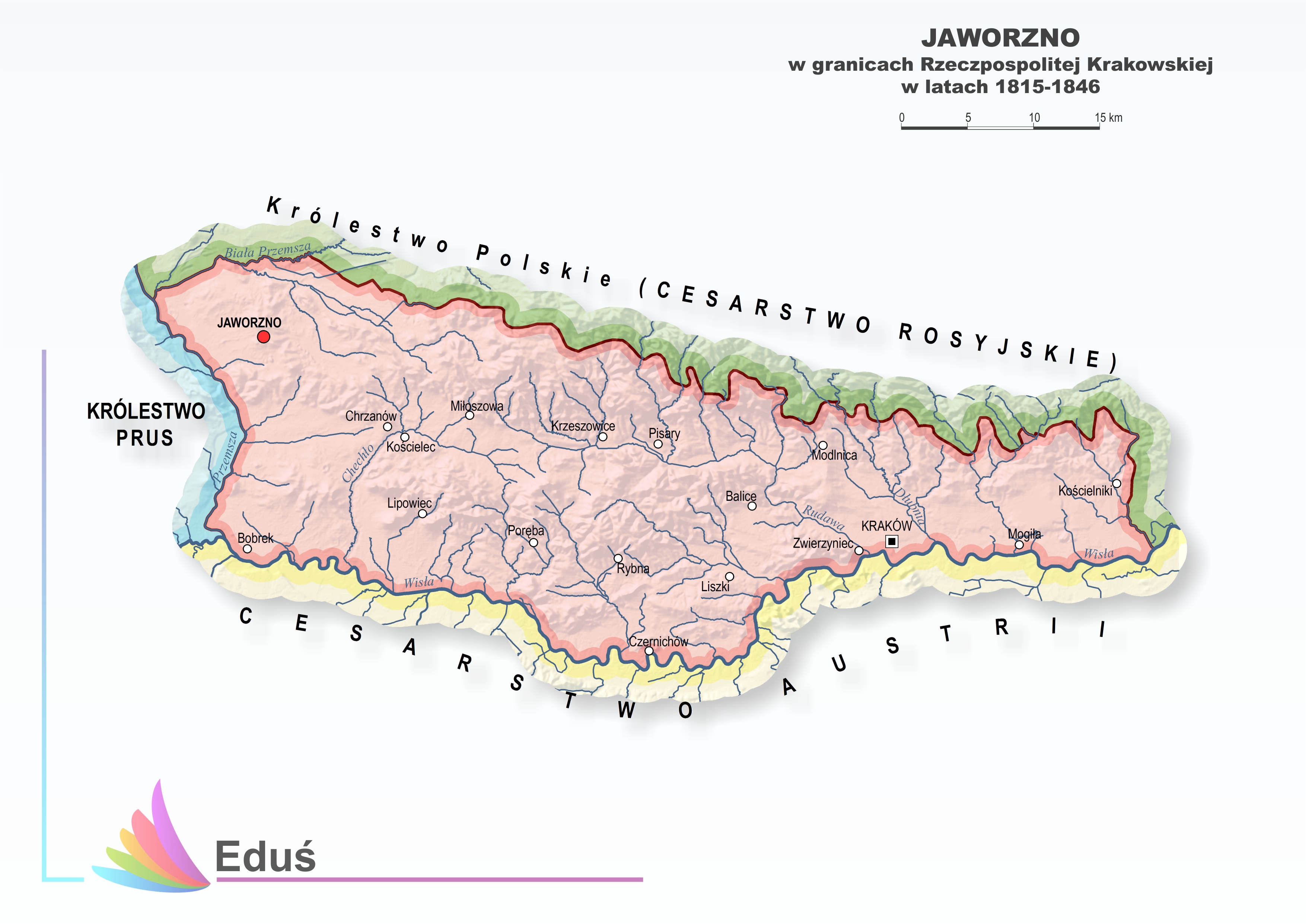